Psary geodata
Psary (Lesser Poland) is a populated place; located in Poland in Europe/Warsaw (GMT+2) time zone. With population of 1,429 people, there are 1927 cities with bigger population in this country. Compared to other cities in Poland, 75.2% of cities are located further ↑North; 50.5% of cities are located further →East and 93.4% of cities have lower elevation than Psary. Note1


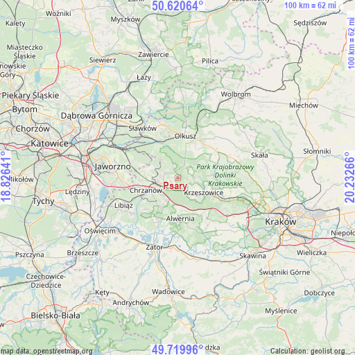
Psary GPS coordinates[2]
50° 10' 20.712" North, 19° 31' 46.308" East
| Map corner | latitude | longitude |
|---|---|---|
| Upper-left | 50.62064°, | 18.82641° |
| Center: | 50.17242°, | 19.52953° |
| Lower-right: | 49.71996°, | 20.23266° |
| Map W x H: | 100.1×100.1 km | = 62.2×62.2mi |
| max Lat: | 54.83135° ⇑75.2% North |
| Psary: | 50.17242° |
| min Lat: | ⇓24.8% South 49.21328° |
| min Long | Psary | max Long |
| 14.20249° | 19.52953° | 24.03723° |
| W 49.5%⇐ | ⇒50.5% E |
Elevation
Elevation of Psary is 378 m = 1240 ft, and this is 186.6 m = 612 ft above average elevation for this country.
| Max E: |
974 m = 3196 ft | 6.6% |
| Psary | 378 m 1240 ft | |
| Avg. | 191.4 m = 628 ft | |
Min E: |
-3 m = -10 ft | 93.4% |
See also: Poland elevation on elevation.city.
Geographical zone
Psary is located in North temperate zone (between Tropic of Cancer and the Arctic Circle). Distance of this North polar circle is 1822.5 km =1132.4 mi to North.| Distance of | km | miles | from Psary |
|---|---|---|---|
| North Pole | 4428.4 | 2751.7 | to North |
| Arctic Circle | 1822.5 | 1132.4 | to North |
| Tropic Cancer | 2972.7 | 1847.1 | to South |
| Equator | 5578.7 | 3466.4 | to South |


Nearby cities:
15 places around Psary: (largest is in red/bold)
• Bolęcin
7 km =4.3 mi,  209°
209°
• Filipowice
3.2 km =2 mi,  125°
125°
• Gorenice
7.6 km =4.7 mi,  58°
58°
• Krzeszowice
8 km =5 mi,  114°
114°
• Lgota
4.2 km =2.6 mi,  25°
25°
• Miękinia
5.9 km =3.7 mi, 108°
• Myślachowice
3.7 km =2.3 mi,  292°
292°
• Niesułowice
5.9 km =3.7 mi,  19°
19°
• Nowa Góra
4.4 km =2.7 mi,  89°
89°
• Ostrężnica
3.7 km =2.3 mi,  52°
52°
• Piła Kościelecka
6.6 km =4.1 mi,  226°
226°
• Płoki
3.8 km =2.4 mi,  344°
344°
• Tenczynek
8.3 km =5.2 mi, 134°
• Trzebinia
4.5 km =2.8 mi,  251°
251°
• Wola Filipowska
5.6 km =3.5 mi,  139°
139°
Sources, notices
• [Note1] Compared only with cities in Poland existing in our database
• [Src1] Map data: © OpenStreetMap contributors (CC-BY-SA)
• [Src2] Other city data from geonames.org with taken over terms of usage.
• [Src3] Geographical zone / Annual Mean Temperature by Robert A. Rohde @ Wikipedia
