Lanckorona geodata
Lanckorona (Lesser Poland) is a seat of a third-order administrative division; located in Poland in Europe/Warsaw (GMT+2) time zone. With population of 2,100 people, there are 1411 cities with bigger population in this country. Compared to other cities in Poland, 90% of cities are located further ↑North; 53.1% of cities are located further ←West and 96.8% of cities have lower elevation than Lanckorona. Note1


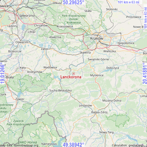
Lanckorona GPS coordinates[2]
49° 50' 41.856" North, 19° 42' 56.808" East
| Map corner | latitude | longitude |
|---|---|---|
| Upper-left | 50.29625°, | 19.01266° |
| Center: | 49.84496°, | 19.71578° |
| Lower-right: | 49.38942°, | 20.41891° |
| Map W x H: | 100.8×100.8 km | = 62.6×62.6mi |
| max Lat: | 54.83135° ⇑90% North |
| Lanckorona: | 49.84496° |
| min Lat: | ⇓10% South 49.21328° |
| min Long | Lanckorona | max Long |
| 14.20249° | 19.71578° | 24.03723° |
| W 53.1%⇐ | ⇒46.9% E |
Elevation
Elevation of Lanckorona is 466 m = 1529 ft, and this is 274.6 m = 901 ft above average elevation for this country.
| Max E: |
974 m = 3196 ft | 3.2% |
| Lanckorona | 466 m 1529 ft | |
| Avg. | 191.4 m = 628 ft | |
Min E: |
-3 m = -10 ft | 96.8% |
See also: Poland elevation on elevation.city.
Geographical zone
Lanckorona is located in North temperate zone (between Tropic of Cancer and the Arctic Circle). Distance of this North polar circle is 1858.9 km =1155.1 mi to North.| Distance of | km | miles | from Lanckorona |
|---|---|---|---|
| North Pole | 4464.8 | 2774.3 | to North |
| Arctic Circle | 1858.9 | 1155.1 | to North |
| Tropic Cancer | 2936.3 | 1824.5 | to South |
| Equator | 5542.2 | 3443.8 | to South |


Nearby cities:
15 places around Lanckorona: (largest is in red/bold)
• Baczyn
5.8 km =3.6 mi,  176°
176°
• Brody
2.8 km =1.7 mi,  332°
332°
• Harbutowice
5.9 km =3.7 mi,  128°
128°
• Izdebnik
4.8 km =3 mi,  51°
51°
• Jastrzębia
3 km =1.9 mi,  86°
86°
• Kalwaria Zebrzydowska
3.7 km =2.3 mi,  312°
312°
• Leńcze
6.2 km =3.9 mi,  13°
13°
• Palcza
4.9 km =3 mi,  155°
155°
• Skawinki
2.5 km =1.6 mi,  185°
185°
• Stronie
3.3 km =2.1 mi,  241°
241°
• Sułkowice
6.1 km =3.8 mi, 94°
• Zachełmna
5.5 km =3.4 mi,  200°
200°
• Zakrzów
5.2 km =3.2 mi,  245°
245°
• Zarzyce Wielkie
4.2 km =2.6 mi,  15°
15°
• Zebrzydowice
5.9 km =3.7 mi, 328°
Sources, notices
• [Note1] Compared only with cities in Poland existing in our database
• [Src1] Map data: © OpenStreetMap contributors (CC-BY-SA)
• [Src2] Other city data from geonames.org with taken over terms of usage.
• [Src3] Geographical zone / Annual Mean Temperature by Robert A. Rohde @ Wikipedia
