Jastrzębia geodata
Jastrzębia (Lesser Poland) is a populated place; located in Poland in Europe/Warsaw (GMT+2) time zone. With population of 625 people, there are 3221 cities with bigger population in this country. Compared to other cities in Poland, 89.9% of cities are located further ↑North; 53.8% of cities are located further ←West and 87.3% of cities have lower elevation than Jastrzębia. Note1


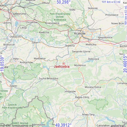
Jastrzębia GPS coordinates[2]
49° 50' 48.228" North, 19° 45' 25.272" East
| Map corner | latitude | longitude |
|---|---|---|
| Upper-left | 50.298°, | 19.0539° |
| Center: | 49.84673°, | 19.75702° |
| Lower-right: | 49.3912°, | 20.46015° |
| Map W x H: | 100.8×100.8 km | = 62.6×62.6mi |
| max Lat: | 54.83135° ⇑89.9% North |
| Jastrzębia: | 49.84673° |
| min Lat: | ⇓10.1% South 49.21328° |
| min Long | Jastrzębia | max Long |
| 14.20249° | 19.75702° | 24.03723° |
| W 53.8%⇐ | ⇒46.2% E |
Elevation
Elevation of Jastrzębia is 304 m = 997 ft, and this is 112.6 m = 369 ft above average elevation for this country.
| Max E: |
974 m = 3196 ft | 12.7% |
| Jastrzębia | 304 m 997 ft | |
| Avg. | 191.4 m = 628 ft | |
Min E: |
-3 m = -10 ft | 87.3% |
See also: Poland elevation on elevation.city.
Geographical zone
Jastrzębia is located in North temperate zone (between Tropic of Cancer and the Arctic Circle). Distance of this North polar circle is 1858.7 km =1154.9 mi to North.| Distance of | km | miles | from Jastrzębia |
|---|---|---|---|
| North Pole | 4464.6 | 2774.2 | to North |
| Arctic Circle | 1858.7 | 1154.9 | to North |
| Tropic Cancer | 2936.5 | 1824.7 | to South |
| Equator | 5542.4 | 3443.9 | to South |


Nearby cities:
15 places around Jastrzębia: (largest is in red/bold)
• Baczyn
6.6 km =4.1 mi,  203°
203°
• Biertowice
3.8 km =2.4 mi,  42°
42°
• Brody
4.8 km =3 mi,  298°
298°
• Harbutowice
4.2 km =2.6 mi,  156°
156°
• Izdebnik
2.9 km =1.8 mi,  15°
15°
• Jasienica
6.6 km =4.1 mi,  113°
113°
• Kalwaria Zebrzydowska
6.2 km =3.9 mi,  292°
292°
• Lanckorona
3 km =1.9 mi,  266°
266°
• Leńcze
6 km =3.7 mi,  345°
345°
• Palcza
4.8 km =3 mi,  191°
191°
• Rudnik
6.5 km =4 mi,  84°
84°
• Skawinki
4.2 km =2.6 mi,  230°
230°
• Stronie
6.2 km =3.9 mi,  253°
253°
• Sułkowice
3.2 km =2 mi,  102°
102°
• Zarzyce Wielkie
4.3 km =2.7 mi,  334°
334°
Sources, notices
• [Note1] Compared only with cities in Poland existing in our database
• [Src1] Map data: © OpenStreetMap contributors (CC-BY-SA)
• [Src2] Other city data from geonames.org with taken over terms of usage.
• [Src3] Geographical zone / Annual Mean Temperature by Robert A. Rohde @ Wikipedia
