Sułkowice geodata
Sułkowice (Lesser Poland) is a seat of a third-order administrative division; located in Poland in Europe/Warsaw (GMT+2) time zone. With population of 6,362 people, there are 575 cities with bigger population in this country. Compared to other cities in Poland, 90.2% of cities are located further ↑North; 54.9% of cities are located further ←West and 85.1% of cities have lower elevation than Sułkowice. Note1


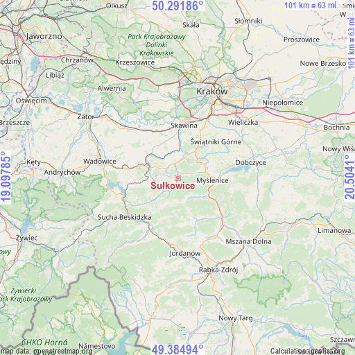
Sułkowice GPS coordinates[2]
49° 50' 25.908" North, 19° 48' 3.492" East
| Map corner | latitude | longitude |
|---|---|---|
| Upper-left | 50.29186°, | 19.09785° |
| Center: | 49.84053°, | 19.80097° |
| Lower-right: | 49.38494°, | 20.5041° |
| Map W x H: | 100.8×100.8 km | = 62.6×62.6mi |
| max Lat: | 54.83135° ⇑90.2% North |
| Sułkowice: | 49.84053° |
| min Lat: | ⇓9.8% South 49.21328° |
| min Long | Sułkowice | max Long |
| 14.20249° | 19.80097° | 24.03723° |
| W 54.9%⇐ | ⇒45.1% E |
Elevation
Elevation of Sułkowice is 290 m = 951 ft, and this is 98.6 m = 323 ft above average elevation for this country.
| Max E: |
974 m = 3196 ft | 14.9% |
| Sułkowice | 290 m 951 ft | |
| Avg. | 191.4 m = 628 ft | |
Min E: |
-3 m = -10 ft | 85.1% |
See also: Poland elevation on elevation.city.
Geographical zone
Sułkowice is located in North temperate zone (between Tropic of Cancer and the Arctic Circle). Distance of this North polar circle is 1859.4 km =1155.4 mi to North.| Distance of | km | miles | from Sułkowice |
|---|---|---|---|
| North Pole | 4465.3 | 2774.6 | to North |
| Arctic Circle | 1859.4 | 1155.4 | to North |
| Tropic Cancer | 2935.8 | 1824.2 | to South |
| Equator | 5541.7 | 3443.5 | to South |


Nearby cities:
15 places around Sułkowice: (largest is in red/bold)
• Biertowice
3.6 km =2.2 mi,  350°
350°
• Bęczarka
6.3 km =3.9 mi,  48°
48°
• Harbutowice
3.5 km =2.2 mi,  205°
205°
• Izdebnik
4.2 km =2.6 mi,  326°
326°
• Jasienica
3.5 km =2.2 mi,  123°
123°
• Jastrzębia
3.2 km =2 mi,  282°
282°
• Jawornik
6.8 km =4.2 mi,  75°
75°
• Krzywaczka
6.3 km =3.9 mi,  20°
20°
• Lanckorona
6.1 km =3.8 mi,  274°
274°
• Palcza
5.7 km =3.5 mi,  225°
225°
• Rudnik
3.6 km =2.2 mi,  68°
68°
• Skawinki
6.6 km =4.1 mi,  252°
252°
• Trzebunia
6.4 km =4 mi,  148°
148°
• Wola Radziszowska
7.3 km =4.5 mi, 352°
• Zarzyce Wielkie
6.8 km =4.2 mi,  312°
312°
Sources, notices
• [Note1] Compared only with cities in Poland existing in our database
• [Src1] Map data: © OpenStreetMap contributors (CC-BY-SA)
• [Src2] Other city data from geonames.org with taken over terms of usage.
• [Src3] Geographical zone / Annual Mean Temperature by Robert A. Rohde @ Wikipedia
