Krzyżowa geodata
Krzyżowa (Silesia) is a populated place; located in Poland in Europe/Warsaw (GMT+2) time zone. With population of 1,400 people, there are 1959 cities with bigger population in this country. Compared to other cities in Poland, 96.6% of cities are located further ↑North; 53.7% of cities are located further →East and 98.1% of cities have lower elevation than Krzyżowa. Note1


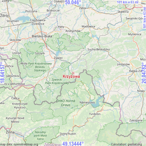
Krzyżowa GPS coordinates[2]
49° 35' 32.46" North, 19° 20' 40.884" East
| Map corner | latitude | longitude |
|---|---|---|
| Upper-left | 50.046°, | 18.64157° |
| Center: | 49.59235°, | 19.34469° |
| Lower-right: | 49.13444°, | 20.04782° |
| Map W x H: | 101.4×101.4 km | = 63×63mi |
| max Lat: | 54.83135° ⇑96.6% North |
| Krzyżowa: | 49.59235° |
| min Lat: | ⇓3.4% South 49.21328° |
| min Long | Krzyżowa | max Long |
| 14.20249° | 19.34469° | 24.03723° |
| W 46.3%⇐ | ⇒53.7% E |
Elevation
Elevation of Krzyżowa is 548 m = 1798 ft, and this is 356.6 m = 1170 ft above average elevation for this country.
| Max E: |
974 m = 3196 ft | 1.9% |
| Krzyżowa | 548 m 1798 ft | |
| Avg. | 191.4 m = 628 ft | |
Min E: |
-3 m = -10 ft | 98.1% |
See also: Poland elevation on elevation.city.
Geographical zone
Krzyżowa is located in North temperate zone (between Tropic of Cancer and the Arctic Circle). Distance of this North polar circle is 1887 km =1172.5 mi to North.| Distance of | km | miles | from Krzyżowa |
|---|---|---|---|
| North Pole | 4492.9 | 2791.8 | to North |
| Arctic Circle | 1887 | 1172.5 | to North |
| Tropic Cancer | 2908.2 | 1807.1 | to South |
| Equator | 5514.2 | 3426.4 | to South |


Nearby cities:
15 places around Krzyżowa: (largest is in red/bold)
• Bystra
11.7 km =7.3 mi,  285°
285°
• Gilowice
13.6 km =8.5 mi,  349°
349°
• Jeleśnia
5.7 km =3.5 mi, 347°
• Juszczyna
9.9 km =6.2 mi, 294°
• Korbielów
2.7 km =1.7 mi,  171°
171°
• Koszarawa
7.1 km =4.4 mi,  34°
34°
• Pewel Wielka
9.4 km =5.8 mi,  13°
13°
• Pewel Ślemieńska
10.8 km =6.7 mi,  356°
356°
• Przyborów
4.5 km =2.8 mi,  43°
43°
• Sopotnia Wielka
5.2 km =3.2 mi,  239°
239°
• Trzebinia
10.9 km =6.8 mi,  306°
306°
• Wieprz
13.3 km =8.3 mi,  297°
297°
• Ślemień
14.1 km =8.8 mi, 6°
• Świnna
9.8 km =6.1 mi,  318°
318°
• Żabnica
13.6 km =8.5 mi,  264°
264°
Sources, notices
• [Note1] Compared only with cities in Poland existing in our database
• [Src1] Map data: © OpenStreetMap contributors (CC-BY-SA)
• [Src2] Other city data from geonames.org with taken over terms of usage.
• [Src3] Geographical zone / Annual Mean Temperature by Robert A. Rohde @ Wikipedia
