Przyborów geodata
Przyborów (Silesia) is a populated place; located in Poland in Europe/Warsaw (GMT+2) time zone. With population of 1,793 people, there are 1633 cities with bigger population in this country. Compared to other cities in Poland, 96.2% of cities are located further ↑North; 52.9% of cities are located further →East and 97.8% of cities have lower elevation than Przyborów. Note1


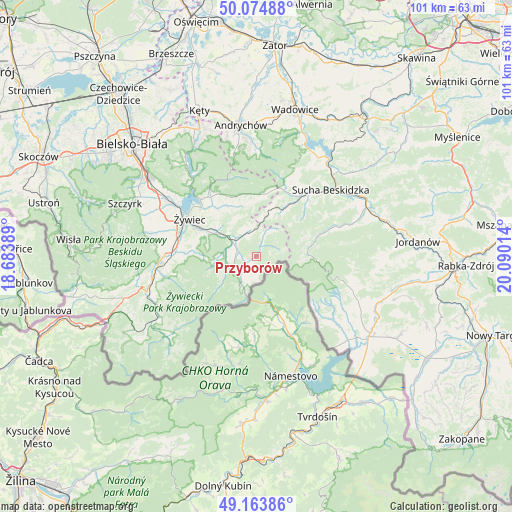
Przyborów GPS coordinates[2]
49° 37' 17.4" North, 19° 23' 13.236" East
| Map corner | latitude | longitude |
|---|---|---|
| Upper-left | 50.07488°, | 18.68389° |
| Center: | 49.6215°, | 19.38701° |
| Lower-right: | 49.16386°, | 20.09014° |
| Map W x H: | 101.3×101.3 km | = 62.9×62.9mi |
| max Lat: | 54.83135° ⇑96.2% North |
| Przyborów: | 49.6215° |
| min Lat: | ⇓3.8% South 49.21328° |
| min Long | Przyborów | max Long |
| 14.20249° | 19.38701° | 24.03723° |
| W 47.1%⇐ | ⇒52.9% E |
Elevation
Elevation of Przyborów is 520 m = 1706 ft, and this is 328.6 m = 1078 ft above average elevation for this country.
| Max E: |
974 m = 3196 ft | 2.2% |
| Przyborów | 520 m 1706 ft | |
| Avg. | 191.4 m = 628 ft | |
Min E: |
-3 m = -10 ft | 97.8% |
See also: Poland elevation on elevation.city.
Geographical zone
Przyborów is located in North temperate zone (between Tropic of Cancer and the Arctic Circle). Distance of this North polar circle is 1883.8 km =1170.5 mi to North.| Distance of | km | miles | from Przyborów |
|---|---|---|---|
| North Pole | 4489.7 | 2789.8 | to North |
| Arctic Circle | 1883.8 | 1170.5 | to North |
| Tropic Cancer | 2911.5 | 1809.1 | to South |
| Equator | 5517.4 | 3428.4 | to South |


Nearby cities:
15 places around Przyborów: (largest is in red/bold)
• Gilowice
11.5 km =7.1 mi,  331°
331°
• Jeleśnia
4.9 km =3 mi,  298°
298°
• Juszczyna
12 km =7.5 mi,  274°
274°
• Korbielów
6.5 km =4 mi,  204°
204°
• Koszarawa
2.8 km =1.7 mi,  21°
21°
• Krzyżowa
4.5 km =2.8 mi,  223°
223°
• Kurów
11.7 km =7.3 mi, 17°
• Lachowice
12.2 km =7.6 mi,  31°
31°
• Pewel Wielka
6 km =3.7 mi,  351°
351°
• Pewel Ślemieńska
8.5 km =5.3 mi, 333°
• Sopotnia Wielka
9.5 km =5.9 mi,  231°
231°
• Trzebinia
12.3 km =7.6 mi,  285°
285°
• Zawoja
11.5 km =7.1 mi,  77°
77°
• Ślemień
10.9 km =6.8 mi, 352°
• Świnna
10.4 km =6.5 mi, 292°
Sources, notices
• [Note1] Compared only with cities in Poland existing in our database
• [Src1] Map data: © OpenStreetMap contributors (CC-BY-SA)
• [Src2] Other city data from geonames.org with taken over terms of usage.
• [Src3] Geographical zone / Annual Mean Temperature by Robert A. Rohde @ Wikipedia
