Ślemień geodata
Ślemień (Silesia) is a populated place; located in Poland in Europe/Warsaw (GMT+2) time zone. With population of 1,977 people, there are 1509 cities with bigger population in this country. Compared to other cities in Poland, 94.1% of cities are located further ↑North; 53.2% of cities are located further →East and 96% of cities have lower elevation than Ślemień. Note1


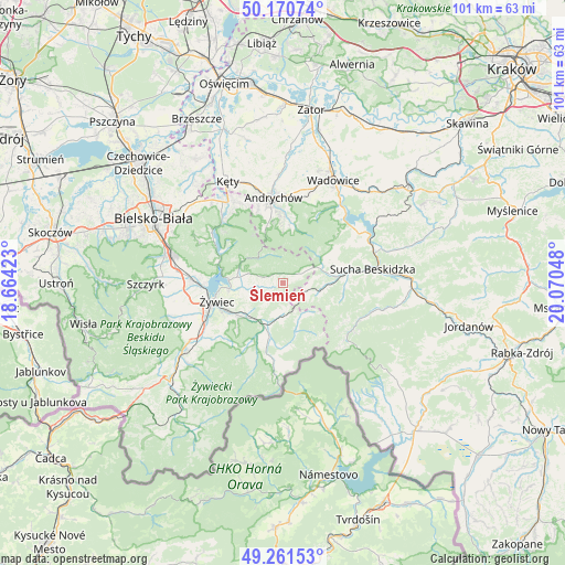
Ślemień GPS coordinates[2]
49° 43' 5.736" North, 19° 22' 2.46" East
| Map corner | latitude | longitude |
|---|---|---|
| Upper-left | 50.17074°, | 18.66423° |
| Center: | 49.71826°, | 19.36735° |
| Lower-right: | 49.26153°, | 20.07048° |
| Map W x H: | 101.1×101.1 km | = 62.8×62.8mi |
| max Lat: | 54.83135° ⇑94.1% North |
| Ślemień: | 49.71826° |
| min Lat: | ⇓5.9% South 49.21328° |
| min Long | Ślemień | max Long |
| 14.20249° | 19.36735° | 24.03723° |
| W 46.8%⇐ | ⇒53.2% E |
Elevation
Elevation of Ślemień is 444 m = 1457 ft, and this is 252.6 m = 829 ft above average elevation for this country.
| Max E: |
974 m = 3196 ft | 4% |
| Ślemień | 444 m 1457 ft | |
| Avg. | 191.4 m = 628 ft | |
Min E: |
-3 m = -10 ft | 96% |
See also: Poland elevation on elevation.city.
Geographical zone
Ślemień is located in North temperate zone (between Tropic of Cancer and the Arctic Circle). Distance of this North polar circle is 1873 km =1163.8 mi to North.| Distance of | km | miles | from Ślemień |
|---|---|---|---|
| North Pole | 4478.9 | 2783.1 | to North |
| Arctic Circle | 1873 | 1163.8 | to North |
| Tropic Cancer | 2922.2 | 1815.8 | to South |
| Equator | 5528.2 | 3435.1 | to South |


Nearby cities:
15 places around Ślemień: (largest is in red/bold)
• Gilowice
4.1 km =2.5 mi,  261°
261°
• Jeleśnia
8.9 km =5.5 mi,  199°
199°
• Koszarawa
8.5 km =5.3 mi,  163°
163°
• Krzeszów
9.9 km =6.2 mi,  62°
62°
• Kuków
8.6 km =5.3 mi,  79°
79°
• Kurów
4.9 km =3 mi,  85°
85°
• Lachowice
7.7 km =4.8 mi, 92°
• Pewel Wielka
4.9 km =3 mi,  173°
173°
• Pewel Ślemieńska
4 km =2.5 mi,  216°
216°
• Przyborów
10.9 km =6.8 mi, 172°
• Rzyki
10.5 km =6.5 mi,  11°
11°
• Stryszawa
11.1 km =6.9 mi, 92°
• Targanice
10.2 km =6.3 mi,  342°
342°
• Łękawica
7.4 km =4.6 mi,  273°
273°
• Świnna
10.5 km =6.5 mi,  230°
230°
Sources, notices
• [Note1] Compared only with cities in Poland existing in our database
• [Src1] Map data: © OpenStreetMap contributors (CC-BY-SA)
• [Src2] Other city data from geonames.org with taken over terms of usage.
• [Src3] Geographical zone / Annual Mean Temperature by Robert A. Rohde @ Wikipedia
