Koziegłowy geodata
Koziegłowy (Silesia) is a seat of a third-order administrative division; located in Poland in Europe/Warsaw (GMT+2) time zone. With population of 2,481 people, there are 1259 cities with bigger population in this country. Compared to other cities in Poland, 65.1% of cities are located further ↑North; 56.9% of cities are located further →East and 86.9% of cities have lower elevation than Koziegłowy. Note1


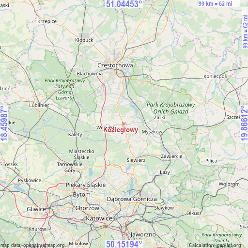
Koziegłowy GPS coordinates[2]
50° 36' 1.26" North, 19° 9' 46.764" East
| Map corner | latitude | longitude |
|---|---|---|
| Upper-left | 51.04453°, | 18.45987° |
| Center: | 50.60035°, | 19.16299° |
| Lower-right: | 50.15194°, | 19.86612° |
| Map W x H: | 99.2×99.2 km | = 61.6×61.6mi |
| max Lat: | 54.83135° ⇑65.1% North |
| Koziegłowy: | 50.60035° |
| min Lat: | ⇓34.9% South 49.21328° |
| min Long | Koziegłowy | max Long |
| 14.20249° | 19.16299° | 24.03723° |
| W 43.1%⇐ | ⇒56.9% E |
Elevation
Elevation of Koziegłowy is 300 m = 984 ft, and this is 108.6 m = 356 ft above average elevation for this country.
| Max E: |
974 m = 3196 ft | 13.1% |
| Koziegłowy | 300 m 984 ft | |
| Avg. | 191.4 m = 628 ft | |
Min E: |
-3 m = -10 ft | 86.9% |
See also: Poland elevation on elevation.city.
Geographical zone
Koziegłowy is located in North temperate zone (between Tropic of Cancer and the Arctic Circle). Distance of this North polar circle is 1774.9 km =1102.9 mi to North.| Distance of | km | miles | from Koziegłowy |
|---|---|---|---|
| North Pole | 4380.8 | 2722.1 | to North |
| Arctic Circle | 1774.9 | 1102.9 | to North |
| Tropic Cancer | 3020.3 | 1876.7 | to South |
| Equator | 5626.2 | 3496 | to South |


Nearby cities:
15 places around Koziegłowy: (largest is in red/bold)
• Choroń
11.4 km =7.1 mi,  37°
37°
• Cynków
5.2 km =3.2 mi,  215°
215°
• Gniazdów
3.7 km =2.3 mi,  262°
262°
• Jastrząb
7.9 km =4.9 mi,  9°
9°
• Kamienica Polska
8.3 km =5.2 mi,  340°
340°
• Koziegłówki
2.1 km =1.3 mi,  135°
135°
• Lgota Górna
5.6 km =3.5 mi,  89°
89°
• Lubsza
11.5 km =7.1 mi,  272°
272°
• Pińczyce
8.4 km =5.2 mi,  146°
146°
• Poraj
9.4 km =5.8 mi,  23°
23°
• Rudnik Wielki
8.8 km =5.5 mi,  322°
322°
• Siedlec Duży
3.9 km =2.4 mi,  325°
325°
• Starcza
11.1 km =6.9 mi,  309°
309°
• Wożniki
7.4 km =4.6 mi, 260°
• Żarki-Letnisko
8.3 km =5.2 mi,  72°
72°
Sources, notices
• [Note1] Compared only with cities in Poland existing in our database
• [Src1] Map data: © OpenStreetMap contributors (CC-BY-SA)
• [Src2] Other city data from geonames.org with taken over terms of usage.
• [Src3] Geographical zone / Annual Mean Temperature by Robert A. Rohde @ Wikipedia
