Poraj geodata
Poraj (Silesia) is a populated place; located in Poland in Europe/Warsaw (GMT+2) time zone. With population of 4,418 people, there are 747 cities with bigger population in this country. Compared to other cities in Poland, 63.1% of cities are located further ↑North; 55.7% of cities are located further →East and 81.4% of cities have lower elevation than Poraj. Note1


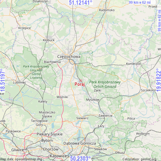
Poraj GPS coordinates[2]
50° 40' 40.692" North, 19° 12' 54.324" East
| Map corner | latitude | longitude |
|---|---|---|
| Upper-left | 51.12141°, | 18.51197° |
| Center: | 50.67797°, | 19.21509° |
| Lower-right: | 50.2303°, | 19.91822° |
| Map W x H: | 99.1×99.1 km | = 61.6×61.6mi |
| max Lat: | 54.83135° ⇑63.1% North |
| Poraj: | 50.67797° |
| min Lat: | ⇓36.9% South 49.21328° |
| min Long | Poraj | max Long |
| 14.20249° | 19.21509° | 24.03723° |
| W 44.3%⇐ | ⇒55.7% E |
Elevation
Elevation of Poraj is 273 m = 896 ft, and this is 81.6 m = 268 ft above average elevation for this country.
| Max E: |
974 m = 3196 ft | 18.6% |
| Poraj | 273 m 896 ft | |
| Avg. | 191.4 m = 628 ft | |
Min E: |
-3 m = -10 ft | 81.4% |
See also: Poland elevation on elevation.city.
Geographical zone
Poraj is located in North temperate zone (between Tropic of Cancer and the Arctic Circle). Distance of this North polar circle is 1766.3 km =1097.5 mi to North.| Distance of | km | miles | from Poraj |
|---|---|---|---|
| North Pole | 4372.2 | 2716.8 | to North |
| Arctic Circle | 1766.3 | 1097.5 | to North |
| Tropic Cancer | 3028.9 | 1882.1 | to South |
| Equator | 5634.9 | 3501.4 | to South |


Nearby cities:
15 places around Poraj: (largest is in red/bold)
• Choroń
3.2 km =2 mi,  82°
82°
• Huta Stara B
8.8 km =5.5 mi,  319°
319°
• Jastrząb
2.5 km =1.6 mi,  249°
249°
• Kamienica Polska
6.6 km =4.1 mi,  263°
263°
• Koziegłowy
9.4 km =5.8 mi,  203°
203°
• Koziegłówki
10.4 km =6.5 mi,  192°
192°
• Lgota Górna
8.8 km =5.5 mi,  167°
167°
• Olsztyn
9 km =5.6 mi,  24°
24°
• Poczesna
7 km =4.3 mi,  305°
305°
• Przybynów
7.7 km =4.8 mi,  110°
110°
• Rudnik Wielki
9.2 km =5.7 mi, 259°
• Siedlec
10.7 km =6.6 mi, 80°
• Siedlec Duży
8 km =5 mi,  227°
227°
• Wysoka Lelowska
9.8 km =6.1 mi,  118°
118°
• Żarki-Letnisko
7.4 km =4.6 mi,  145°
145°
Sources, notices
• [Note1] Compared only with cities in Poland existing in our database
• [Src1] Map data: © OpenStreetMap contributors (CC-BY-SA)
• [Src2] Other city data from geonames.org with taken over terms of usage.
• [Src3] Geographical zone / Annual Mean Temperature by Robert A. Rohde @ Wikipedia
