Żarki-Letnisko geodata
Żarki-Letnisko (Silesia) is a populated place; located in Poland in Europe/Warsaw (GMT+2) time zone. With population of 2,344 people, there are 1304 cities with bigger population in this country. Compared to other cities in Poland, 64.6% of cities are located further ↑North; 54.7% of cities are located further →East and 85.4% of cities have lower elevation than Żarki-Letnisko. Note1


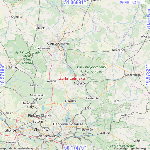
Żarki-Letnisko GPS coordinates[2]
50° 37' 22.62" North, 19° 16' 30.288" East
| Map corner | latitude | longitude |
|---|---|---|
| Upper-left | 51.06691°, | 18.57196° |
| Center: | 50.62295°, | 19.27508° |
| Lower-right: | 50.17475°, | 19.97821° |
| Map W x H: | 99.2×99.2 km | = 61.6×61.6mi |
| max Lat: | 54.83135° ⇑64.6% North |
| Żarki-Letnisko: | 50.62295° |
| min Lat: | ⇓35.4% South 49.21328° |
| min Long | Żarki-Letnisko | max Long |
| 14.20249° | 19.27508° | 24.03723° |
| W 45.3%⇐ | ⇒54.7% E |
Elevation
Elevation of Żarki-Letnisko is 292 m = 958 ft, and this is 100.6 m = 330 ft above average elevation for this country.
| Max E: |
974 m = 3196 ft | 14.6% |
| Żarki-Letnisko | 292 m 958 ft | |
| Avg. | 191.4 m = 628 ft | |
Min E: |
-3 m = -10 ft | 85.4% |
See also: Poland elevation on elevation.city.
Geographical zone
Żarki-Letnisko is located in North temperate zone (between Tropic of Cancer and the Arctic Circle). Distance of this North polar circle is 1772.4 km =1101.3 mi to North.| Distance of | km | miles | from Żarki-Letnisko |
|---|---|---|---|
| North Pole | 4378.3 | 2720.5 | to North |
| Arctic Circle | 1772.4 | 1101.3 | to North |
| Tropic Cancer | 3022.8 | 1878.3 | to South |
| Equator | 5628.7 | 3497.5 | to South |


Nearby cities:
15 places around Żarki-Letnisko: (largest is in red/bold)
• Choroń
6.6 km =4.1 mi,  351°
351°
• Gniazdów
11.9 km =7.4 mi,  255°
255°
• Jastrząb
8.4 km =5.2 mi,  308°
308°
• Jaworznik
9.5 km =5.9 mi,  99°
99°
• Koziegłowy
8.3 km =5.2 mi,  252°
252°
• Koziegłówki
7.6 km =4.7 mi,  238°
238°
• Lgota Górna
3.4 km =2.1 mi,  222°
222°
• Myszków
6.4 km =4 mi,  146°
146°
• Pińczyce
10.1 km =6.3 mi,  199°
199°
• Poraj
7.4 km =4.6 mi,  325°
325°
• Przybynów
4.5 km =2.8 mi,  41°
41°
• Siedlec
10.1 km =6.3 mi, 38°
• Siedlec Duży
10.1 km =6.3 mi,  274°
274°
• Wysoka Lelowska
4.6 km =2.9 mi,  72°
72°
• Żarki
6.2 km =3.9 mi,  87°
87°
Sources, notices
• [Note1] Compared only with cities in Poland existing in our database
• [Src1] Map data: © OpenStreetMap contributors (CC-BY-SA)
• [Src2] Other city data from geonames.org with taken over terms of usage.
• [Src3] Geographical zone / Annual Mean Temperature by Robert A. Rohde @ Wikipedia
