Pińczyce geodata
Pińczyce (Silesia) is a populated place; located in Poland in Europe/Warsaw (GMT+2) time zone. With population of 996 people, there are 2504 cities with bigger population in this country. Compared to other cities in Poland, 66.5% of cities are located further ↑North; 55.5% of cities are located further →East and 92.7% of cities have lower elevation than Pińczyce. Note1


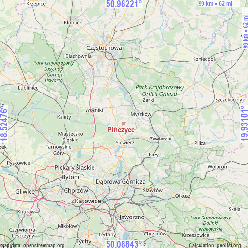
Pińczyce GPS coordinates[2]
50° 32' 14.784" North, 19° 13' 40.368" East
| Map corner | latitude | longitude |
|---|---|---|
| Upper-left | 50.98221°, | 18.52476° |
| Center: | 50.53744°, | 19.22788° |
| Lower-right: | 50.08843°, | 19.93101° |
| Map W x H: | 99.4×99.4 km | = 61.8×61.8mi |
| max Lat: | 54.83135° ⇑66.5% North |
| Pińczyce: | 50.53744° |
| min Lat: | ⇓33.5% South 49.21328° |
| min Long | Pińczyce | max Long |
| 14.20249° | 19.22788° | 24.03723° |
| W 44.5%⇐ | ⇒55.5% E |
Elevation
Elevation of Pińczyce is 365 m = 1198 ft, and this is 173.6 m = 570 ft above average elevation for this country.
| Max E: |
974 m = 3196 ft | 7.3% |
| Pińczyce | 365 m 1198 ft | |
| Avg. | 191.4 m = 628 ft | |
Min E: |
-3 m = -10 ft | 92.7% |
See also: Poland elevation on elevation.city.
Geographical zone
Pińczyce is located in North temperate zone (between Tropic of Cancer and the Arctic Circle). Distance of this North polar circle is 1781.9 km =1107.2 mi to North.| Distance of | km | miles | from Pińczyce |
|---|---|---|---|
| North Pole | 4387.8 | 2726.5 | to North |
| Arctic Circle | 1781.9 | 1107.2 | to North |
| Tropic Cancer | 3013.3 | 1872.4 | to South |
| Equator | 5619.2 | 3491.6 | to South |


Nearby cities:
15 places around Pińczyce: (largest is in red/bold)
• Ciągowice
13.9 km =8.6 mi,  136°
136°
• Cynków
8.1 km =5 mi,  289°
289°
• Gniazdów
10.5 km =6.5 mi,  308°
308°
• Koziegłowy
8.4 km =5.2 mi,  326°
326°
• Koziegłówki
6.3 km =3.9 mi, 330°
• Lgota Górna
7.1 km =4.4 mi,  8°
8°
• Mierzęcice
12.4 km =7.7 mi,  214°
214°
• Myszków
8 km =5 mi,  58°
58°
• Poręba
9.6 km =6 mi,  124°
124°
• Siedlec Duży
12.3 km =7.6 mi, 326°
• Siewierz
7.9 km =4.9 mi,  178°
178°
• Wożniki
13.2 km =8.2 mi,  295°
295°
• Wysoka Lelowska
13.4 km =8.3 mi,  35°
35°
• Żarki
13.7 km =8.5 mi, 44°
• Żarki-Letnisko
10.1 km =6.3 mi,  19°
19°
Sources, notices
• [Note1] Compared only with cities in Poland existing in our database
• [Src1] Map data: © OpenStreetMap contributors (CC-BY-SA)
• [Src2] Other city data from geonames.org with taken over terms of usage.
• [Src3] Geographical zone / Annual Mean Temperature by Robert A. Rohde @ Wikipedia
