Stabłowice geodata
Stabłowice (Lower Silesia) is a section of populated place; located in Poland in Europe/Warsaw (GMT+2) time zone. With population of 14,099 people, there are 351 cities with bigger population in this country. Compared to other cities in Poland, 50.2% of cities are located further ↑North; 86% of cities are located further →East and 73.5% of cities have higher elevation than Stabłowice. Note1
Administrative division(s):
- Level 1: Lower Silesia
- Level 2: Wrocław
- Level 3: Wrocław
- Level 4: Leśnica


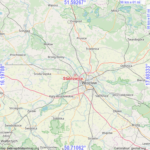
Stabłowice GPS coordinates[2]
51° 9' 13.5" North, 16° 54' 0.72" East
| Map corner | latitude | longitude |
|---|---|---|
| Upper-left | 51.59267°, | 16.19708° |
| Center: | 51.15375°, | 16.9002° |
| Lower-right: | 50.71062°, | 17.60333° |
| Map W x H: | 98.1×98.1 km | = 61×61mi |
| max Lat: | 54.83135° ⇑50.2% North |
| Stabłowice: | 51.15375° |
| min Lat: | ⇓49.8% South 49.21328° |
| min Long | Stabłowice | max Long |
| 14.20249° | 16.9002° | 24.03723° |
| W 14%⇐ | ⇒86% E |
Elevation
Elevation of Stabłowice is 114 m = 374 ft, and this is 77.4 m = 254 ft below average elevation for this country.
| Max E: |
974 m = 3196 ft | 73.5% |
| Avg. | 191.4 m = 628 ft | |
| Stabłowice | 114 m = 374 ft | |
Min E: |
-3 m = -10 ft | 26.5% |
See also: Poland elevation on elevation.city.
Geographical zone
Stabłowice is located in North temperate zone (between Tropic of Cancer and the Arctic Circle). Distance of this North polar circle is 1713.4 km =1064.7 mi to North.| Distance of | km | miles | from Stabłowice |
|---|---|---|---|
| North Pole | 4319.3 | 2683.9 | to North |
| Arctic Circle | 1713.4 | 1064.7 | to North |
| Tropic Cancer | 3081.8 | 1914.9 | to South |
| Equator | 5687.8 | 3534.2 | to South |


Nearby cities:
15 places around Stabłowice: (largest is in red/bold)
• Gądów Mały
7.2 km =4.5 mi,  123°
123°
• Jarnołtów-Jerzmanowo
4.3 km =2.7 mi,  213°
213°
• Kozanów
4.9 km =3 mi,  102°
102°
• Leśnica-Ratyń-Pustki
3.9 km =2.4 mi,  250°
250°
• Lutynia
8.4 km =5.2 mi,  255°
255°
• Marszowice
2.3 km =1.4 mi,  331°
331°
• Maślice Małe
2.9 km =1.8 mi, 99°
• Maślice Wielkie
2.2 km =1.4 mi,  61°
61°
• Nowe Żerniki-Kolonie Żernickie
2.6 km =1.6 mi,  142°
142°
• Osiedle Kosmonautów
5.2 km =3.2 mi, 124°
• Pilczyce
4.4 km =2.7 mi,  114°
114°
• Pracze Odrzańskie-Janówek
3.8 km =2.4 mi,  8°
8°
• Różanka-Polanka
8.4 km =5.2 mi, 97°
• Strachowice-Osiniec
5.3 km =3.3 mi,  187°
187°
• Złotniki
1.9 km =1.2 mi,  203°
203°
Sources, notices
• [Note1] Compared only with cities in Poland existing in our database
• [Src1] Map data: © OpenStreetMap contributors (CC-BY-SA)
• [Src2] Other city data from geonames.org with taken over terms of usage.
• [Src3] Geographical zone / Annual Mean Temperature by Robert A. Rohde @ Wikipedia
