Różanka-Polanka geodata
Różanka-Polanka (Lower Silesia) is a section of populated place; located in Poland in Europe/Warsaw (GMT+2) time zone. With population of 15,746 people, there are 317 cities with bigger population in this country. Compared to other cities in Poland, 50.8% of cities are located further ↑North; 84.5% of cities are located further →East and 75% of cities have higher elevation than Różanka-Polanka. Note1
Administrative division(s):
- Level 1: Lower Silesia
- Level 2: Wrocław
- Level 3: Wrocław
- Level 4: Karłowice - Różanka


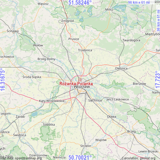
Różanka-Polanka GPS coordinates[2]
51° 8' 36.384" North, 17° 1' 11.532" East
| Map corner | latitude | longitude |
|---|---|---|
| Upper-left | 51.58246°, | 16.31675° |
| Center: | 51.14344°, | 17.01987° |
| Lower-right: | 50.70021°, | 17.723° |
| Map W x H: | 98.1×98.1 km | = 61×61mi |
| max Lat: | 54.83135° ⇑50.8% North |
| Różanka-Polanka: | 51.14344° |
| min Lat: | ⇓49.2% South 49.21328° |
| min Long | Różanka-Polan | max Long |
| 14.20249° | 17.01987° | 24.03723° |
| W 15.5%⇐ | ⇒84.5% E |
Elevation
Elevation of Różanka-Polanka is 111 m = 364 ft, and this is 80.4 m = 264 ft below average elevation for this country.
| Max E: |
974 m = 3196 ft | 75% |
| Avg. | 191.4 m = 628 ft | |
| Różanka-Polanka | 111 m = 364 ft | |
Min E: |
-3 m = -10 ft | 25% |
See also: Poland elevation on elevation.city.
Geographical zone
Różanka-Polanka is located in North temperate zone (between Tropic of Cancer and the Arctic Circle). Distance of this North polar circle is 1714.6 km =1065.4 mi to North.| Distance of | km | miles | from Różanka-Polanka |
|---|---|---|---|
| North Pole | 4320.4 | 2684.6 | to North |
| Arctic Circle | 1714.6 | 1065.4 | to North |
| Tropic Cancer | 3080.7 | 1914.3 | to South |
| Equator | 5686.6 | 3533.5 | to South |


Nearby cities:
15 places around Różanka-Polanka: (largest is in red/bold)
• Gądów Mały
3.6 km =2.2 mi,  220°
220°
• Karłowice
2.3 km =1.4 mi,  95°
95°
• Kozanów
3.5 km =2.2 mi,  271°
271°
• Osiedle Kosmonautów
4.4 km =2.7 mi,  246°
246°
• Pilczyce
4.4 km =2.7 mi,  260°
260°
• Poświętne
1.6 km =1 mi,  22°
22°
• Psary
4.9 km =3 mi,  9°
9°
• Rejon alei Kromera
3.7 km =2.3 mi,  106°
106°
• Rejon placu Grunwaldzkiego
4.1 km =2.5 mi,  135°
135°
• Rejon placu Świętego Macieja
2.8 km =1.7 mi,  154°
154°
• Rejon ulicy Klęczkowskiej
1.8 km =1.1 mi, 147°
• Sołtysowice
3.7 km =2.3 mi,  73°
73°
• Widawa-Lipa Piotrowska-Polanowice
3.1 km =1.9 mi,  2°
2°
• Wrocław
4.9 km =3 mi,  168°
168°
• Zacisze
4.4 km =2.7 mi,  120°
120°
Sources, notices
• [Note1] Compared only with cities in Poland existing in our database
• [Src1] Map data: © OpenStreetMap contributors (CC-BY-SA)
• [Src2] Other city data from geonames.org with taken over terms of usage.
• [Src3] Geographical zone / Annual Mean Temperature by Robert A. Rohde @ Wikipedia
