Śródmieście geodata
Śródmieście (Mazovia) is a populated place; located in Poland in Europe/Warsaw (GMT+2) time zone. With population of 134,306 people, there are 30 cities with bigger population in this country. Compared to other cities in Poland, 70.9% of cities are located further ↓South; 73% of cities are located further ←West and 72.6% of cities have higher elevation than Śródmieście. Note1
Administrative division(s):
- Level 1: Mazovia
- Level 2: Warszawa
- Level 3: Warszawa
- Level 4: Śródmieście


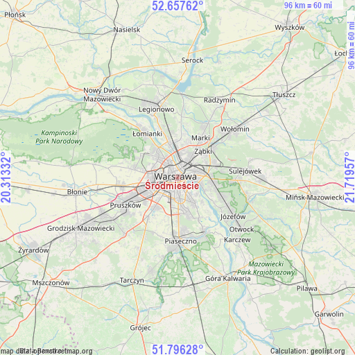
Śródmieście GPS coordinates[2]
52° 13' 44.544" North, 21° 0' 59.184" East
| Map corner | latitude | longitude |
|---|---|---|
| Upper-left | 52.65762°, | 20.31332° |
| Center: | 52.22904°, | 21.01644° |
| Lower-right: | 51.79628°, | 21.71957° |
| Map W x H: | 95.8×95.8 km | = 59.5×59.5mi |
| max Lat: | 54.83135° ⇑29.1% North |
| Śródmieście: | 52.22904° |
| min Lat: | ⇓70.9% South 49.21328° |
| min Long | Śródmieście | max Long |
| 14.20249° | 21.01644° | 24.03723° |
| W 73%⇐ | ⇒27% E |
Elevation
Elevation of Śródmieście is 116 m = 381 ft, and this is 75.4 m = 247 ft below average elevation for this country.
| Max E: |
974 m = 3196 ft | 72.6% |
| Avg. | 191.4 m = 628 ft | |
| Śródmieście | 116 m = 381 ft | |
Min E: |
-3 m = -10 ft | 27.4% |
See also: Śródmieście elevation on elevation.city.
Geographical zone
Śródmieście is located in North temperate zone (between Tropic of Cancer and the Arctic Circle). Distance of this North polar circle is 1593.8 km =990.3 mi to North.| Distance of | km | miles | from Śródmieście |
|---|---|---|---|
| North Pole | 4199.7 | 2609.6 | to North |
| Arctic Circle | 1593.8 | 990.3 | to North |
| Tropic Cancer | 3201.4 | 1989.3 | to South |
| Equator | 5807.3 | 3608.5 | to South |


Nearby cities:
15 places around Śródmieście: (largest is in red/bold)
• Bemowo
7.9 km =4.9 mi,  291°
291°
• Bielany
9 km =5.6 mi,  321°
321°
• Mokotów
4.2 km =2.6 mi,  162°
162°
• Ochota
2.3 km =1.4 mi,  247°
247°
• Praga Południe
5 km =3.1 mi,  70°
70°
• Praga Północ
3.1 km =1.9 mi,  23°
23°
• Targówek
7.3 km =4.5 mi, 17°
• Ursus
9.8 km =6.1 mi, 247°
• Ursynów
9 km =5.6 mi,  165°
165°
• Warsaw
0.3 km =0.2 mi,  284°
284°
• Wilanów
8.8 km =5.5 mi,  146°
146°
• Wola
2.3 km =1.4 mi,  303°
303°
• Włochy
7.3 km =4.5 mi,  220°
220°
• Ząbki
9.3 km =5.8 mi,  40°
40°
• Żoliborz
4.9 km =3 mi,  335°
335°
Sources, notices
• [Note1] Compared only with cities in Poland existing in our database
• [Src1] Map data: © OpenStreetMap contributors (CC-BY-SA)
• [Src2] Other city data from geonames.org with taken over terms of usage.
• [Src3] Geographical zone / Annual Mean Temperature by Robert A. Rohde @ Wikipedia
