Górki geodata
Górki (Subcarpathian) is a populated place; located in Poland in Europe/Warsaw (GMT+2) time zone. With population of 1,800 people, there are 1605 cities with bigger population in this country. Compared to other cities in Poland, 95.9% of cities are located further ↑North; 85.4% of cities are located further ←West and 89% of cities have lower elevation than Górki. Note1


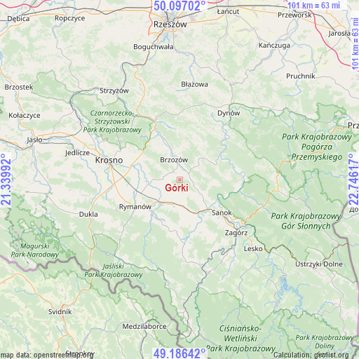
Górki GPS coordinates[2]
49° 38' 37.86" North, 22° 2' 34.944" East
| Map corner | latitude | longitude |
|---|---|---|
| Upper-left | 50.09702°, | 21.33992° |
| Center: | 49.64385°, | 22.04304° |
| Lower-right: | 49.18642°, | 22.74617° |
| Map W x H: | 101.2×101.2 km | = 62.9×62.9mi |
| max Lat: | 54.83135° ⇑95.9% North |
| Górki: | 49.64385° |
| min Lat: | ⇓4.1% South 49.21328° |
| min Long | Górki | max Long |
| 14.20249° | 22.04304° | 24.03723° |
| W 85.4%⇐ | ⇒14.6% E |
Elevation
Elevation of Górki is 317 m = 1040 ft, and this is 125.6 m = 412 ft above average elevation for this country.
| Max E: |
974 m = 3196 ft | 11% |
| Górki | 317 m 1040 ft | |
| Avg. | 191.4 m = 628 ft | |
Min E: |
-3 m = -10 ft | 89% |
See also: Poland elevation on elevation.city.
Geographical zone
Górki is located in North temperate zone (between Tropic of Cancer and the Arctic Circle). Distance of this North polar circle is 1881.3 km =1169 mi to North.| Distance of | km | miles | from Górki |
|---|---|---|---|
| North Pole | 4487.2 | 2788.2 | to North |
| Arctic Circle | 1881.3 | 1169 | to North |
| Tropic Cancer | 2914 | 1810.7 | to South |
| Equator | 5519.9 | 3429.9 | to South |


Nearby cities:
15 places around Górki: (largest is in red/bold)
• Brzozów
5.9 km =3.7 mi,  343°
343°
• Długie
7.2 km =4.5 mi,  179°
179°
• Grabownica Starzeńska
3 km =1.9 mi,  55°
55°
• Humniska
3.6 km =2.2 mi,  12°
12°
• Jabłonka
7.7 km =4.8 mi,  43°
43°
• Jasionów
5 km =3.1 mi,  288°
288°
• Kostarowce
8.2 km =5.1 mi,  141°
141°
• Niebocko
5.8 km =3.6 mi,  49°
49°
• Nowosielce-Gniewosz
8.6 km =5.3 mi,  167°
167°
• Pakoszówka
5.1 km =3.2 mi,  117°
117°
• Stara Wieś
8.4 km =5.2 mi, 340°
• Strachocina
5.1 km =3.2 mi, 140°
• Turze Pole
3.5 km =2.2 mi,  308°
308°
• Zarszyn
7.2 km =4.5 mi,  197°
197°
• Zmiennica
6.6 km =4.1 mi,  303°
303°
Sources, notices
• [Note1] Compared only with cities in Poland existing in our database
• [Src1] Map data: © OpenStreetMap contributors (CC-BY-SA)
• [Src2] Other city data from geonames.org with taken over terms of usage.
• [Src3] Geographical zone / Annual Mean Temperature by Robert A. Rohde @ Wikipedia
