Kostarowce geodata
Kostarowce (Subcarpathian) is a populated place; located in Poland in Europe/Warsaw (GMT+2) time zone. With population of 720 people, there are 3027 cities with bigger population in this country. Compared to other cities in Poland, 96.8% of cities are located further ↑North; 86.4% of cities are located further ←West and 88% of cities have lower elevation than Kostarowce. Note1


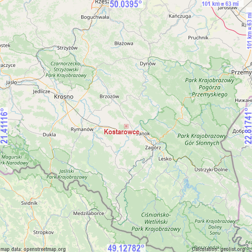
Kostarowce GPS coordinates[2]
49° 35' 8.844" North, 22° 6' 51.408" East
| Map corner | latitude | longitude |
|---|---|---|
| Upper-left | 50.0395°, | 21.41116° |
| Center: | 49.58579°, | 22.11428° |
| Lower-right: | 49.12782°, | 22.81741° |
| Map W x H: | 101.4×101.4 km | = 63×63mi |
| max Lat: | 54.83135° ⇑96.8% North |
| Kostarowce: | 49.58579° |
| min Lat: | ⇓3.2% South 49.21328° |
| min Long | Kostarowce | max Long |
| 14.20249° | 22.11428° | 24.03723° |
| W 86.4%⇐ | ⇒13.6% E |
Elevation
Elevation of Kostarowce is 308 m = 1010 ft, and this is 116.6 m = 383 ft above average elevation for this country.
| Max E: |
974 m = 3196 ft | 12% |
| Kostarowce | 308 m 1010 ft | |
| Avg. | 191.4 m = 628 ft | |
Min E: |
-3 m = -10 ft | 88% |
See also: Poland elevation on elevation.city.
Geographical zone
Kostarowce is located in North temperate zone (between Tropic of Cancer and the Arctic Circle). Distance of this North polar circle is 1887.8 km =1173 mi to North.| Distance of | km | miles | from Kostarowce |
|---|---|---|---|
| North Pole | 4493.6 | 2792.2 | to North |
| Arctic Circle | 1887.8 | 1173 | to North |
| Tropic Cancer | 2907.5 | 1806.6 | to South |
| Equator | 5513.4 | 3425.9 | to South |


Nearby cities:
15 places around Kostarowce: (largest is in red/bold)
• Besko
11.6 km =7.2 mi,  270°
270°
• Długie
5.2 km =3.2 mi,  261°
261°
• Grabownica Starzeńska
8.6 km =5.3 mi,  341°
341°
• Górki
8.2 km =5.1 mi,  321°
321°
• Humniska
10.8 km =6.7 mi, 336°
• Niebieszczany
9.6 km =6 mi,  161°
161°
• Niebocko
10.2 km =6.3 mi,  356°
356°
• Nowosielce-Gniewosz
3.8 km =2.4 mi,  239°
239°
• Pakoszówka
4.2 km =2.6 mi,  351°
351°
• Pielnia
6.9 km =4.3 mi,  219°
219°
• Pisarowce
3.3 km =2.1 mi,  203°
203°
• Sanok
7.4 km =4.6 mi,  116°
116°
• Strachocina
3.1 km =1.9 mi, 323°
• Turze Pole
11.7 km =7.3 mi, 317°
• Zarszyn
7.3 km =4.5 mi, 266°
Sources, notices
• [Note1] Compared only with cities in Poland existing in our database
• [Src1] Map data: © OpenStreetMap contributors (CC-BY-SA)
• [Src2] Other city data from geonames.org with taken over terms of usage.
• [Src3] Geographical zone / Annual Mean Temperature by Robert A. Rohde @ Wikipedia
