Zmiennica geodata
Zmiennica (Subcarpathian) is a populated place; located in Poland in Europe/Warsaw (GMT+2) time zone. With population of 1,100 people, there are 2307 cities with bigger population in this country. Compared to other cities in Poland, 95.1% of cities are located further ↑North; 84.4% of cities are located further ←West and 89% of cities have lower elevation than Zmiennica. Note1


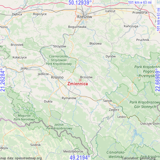
Zmiennica GPS coordinates[2]
49° 40' 35.472" North, 21° 57' 57.456" East
| Map corner | latitude | longitude |
|---|---|---|
| Upper-left | 50.12939°, | 21.26284° |
| Center: | 49.67652°, | 21.96596° |
| Lower-right: | 49.2194°, | 22.66909° |
| Map W x H: | 101.2×101.2 km | = 62.9×62.9mi |
| max Lat: | 54.83135° ⇑95.1% North |
| Zmiennica: | 49.67652° |
| min Lat: | ⇓4.9% South 49.21328° |
| min Long | Zmiennica | max Long |
| 14.20249° | 21.96596° | 24.03723° |
| W 84.4%⇐ | ⇒15.6% E |
Elevation
Elevation of Zmiennica is 317 m = 1040 ft, and this is 125.6 m = 412 ft above average elevation for this country.
| Max E: |
974 m = 3196 ft | 11% |
| Zmiennica | 317 m 1040 ft | |
| Avg. | 191.4 m = 628 ft | |
Min E: |
-3 m = -10 ft | 89% |
See also: Poland elevation on elevation.city.
Geographical zone
Zmiennica is located in North temperate zone (between Tropic of Cancer and the Arctic Circle). Distance of this North polar circle is 1877.7 km =1166.7 mi to North.| Distance of | km | miles | from Zmiennica |
|---|---|---|---|
| North Pole | 4483.6 | 2786 | to North |
| Arctic Circle | 1877.7 | 1166.7 | to North |
| Tropic Cancer | 2917.6 | 1812.9 | to South |
| Equator | 5523.5 | 3432.1 | to South |


Nearby cities:
15 places around Zmiennica: (largest is in red/bold)
• Besko
9.9 km =6.2 mi,  185°
185°
• Blizne
8.6 km =5.3 mi,  3°
3°
• Brzozów
4.4 km =2.7 mi,  61°
61°
• Grabownica Starzeńska
8.3 km =5.2 mi,  103°
103°
• Górki
6.6 km =4.1 mi,  123°
123°
• Haczów
5.2 km =3.2 mi,  251°
251°
• Humniska
6.3 km =3.9 mi,  91°
91°
• Jabłonica Polska
5.3 km =3.3 mi,  296°
296°
• Jasienica Rosielna
8.5 km =5.3 mi,  348°
348°
• Jasionów
2.2 km =1.4 mi,  158°
158°
• Krościenko Wyżne
9.9 km =6.2 mi,  271°
271°
• Malinówka
3.5 km =2.2 mi,  309°
309°
• Orzechówka
6.2 km =3.9 mi, 346°
• Stara Wieś
5.1 km =3.2 mi,  32°
32°
• Turze Pole
3.2 km =2 mi, 117°
Sources, notices
• [Note1] Compared only with cities in Poland existing in our database
• [Src1] Map data: © OpenStreetMap contributors (CC-BY-SA)
• [Src2] Other city data from geonames.org with taken over terms of usage.
• [Src3] Geographical zone / Annual Mean Temperature by Robert A. Rohde @ Wikipedia
