Strachocina geodata
Strachocina (Subcarpathian) is a populated place; located in Poland in Europe/Warsaw (GMT+2) time zone. With population of 1,100 people, there are 2307 cities with bigger population in this country. Compared to other cities in Poland, 96.5% of cities are located further ↑North; 85.9% of cities are located further ←West and 88.8% of cities have lower elevation than Strachocina. Note1


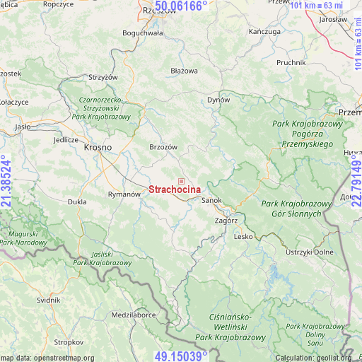
Strachocina GPS coordinates[2]
49° 36' 29.34" North, 22° 5' 18.096" East
| Map corner | latitude | longitude |
|---|---|---|
| Upper-left | 50.06166°, | 21.38524° |
| Center: | 49.60815°, | 22.08836° |
| Lower-right: | 49.15039°, | 22.79149° |
| Map W x H: | 101.3×101.3 km | = 62.9×62.9mi |
| max Lat: | 54.83135° ⇑96.5% North |
| Strachocina: | 49.60815° |
| min Lat: | ⇓3.5% South 49.21328° |
| min Long | Strachocina | max Long |
| 14.20249° | 22.08836° | 24.03723° |
| W 85.9%⇐ | ⇒14.1% E |
Elevation
Elevation of Strachocina is 315 m = 1033 ft, and this is 123.6 m = 406 ft above average elevation for this country.
| Max E: |
974 m = 3196 ft | 11.2% |
| Strachocina | 315 m 1033 ft | |
| Avg. | 191.4 m = 628 ft | |
Min E: |
-3 m = -10 ft | 88.8% |
See also: Poland elevation on elevation.city.
Geographical zone
Strachocina is located in North temperate zone (between Tropic of Cancer and the Arctic Circle). Distance of this North polar circle is 1885.3 km =1171.5 mi to North.| Distance of | km | miles | from Strachocina |
|---|---|---|---|
| North Pole | 4491.2 | 2790.7 | to North |
| Arctic Circle | 1885.3 | 1171.5 | to North |
| Tropic Cancer | 2910 | 1808.2 | to South |
| Equator | 5515.9 | 3427.4 | to South |


Nearby cities:
15 places around Strachocina: (largest is in red/bold)
• Besko
10 km =6.2 mi,  256°
256°
• Długie
4.6 km =2.9 mi,  224°
224°
• Grabownica Starzeńska
5.7 km =3.5 mi,  352°
352°
• Górki
5.1 km =3.2 mi,  320°
320°
• Humniska
7.8 km =4.8 mi,  341°
341°
• Jabłonka
9.8 km =6.1 mi,  11°
11°
• Jasionów
9.8 km =6.1 mi,  304°
304°
• Kostarowce
3.1 km =1.9 mi,  143°
143°
• Niebocko
7.8 km =4.8 mi, 8°
• Nowosielce-Gniewosz
4.6 km =2.9 mi,  197°
197°
• Pakoszówka
2 km =1.2 mi,  36°
36°
• Pielnia
8.2 km =5.1 mi, 198°
• Pisarowce
5.5 km =3.4 mi,  174°
174°
• Turze Pole
8.6 km =5.3 mi, 315°
• Zarszyn
6.2 km =3.9 mi,  241°
241°
Sources, notices
• [Note1] Compared only with cities in Poland existing in our database
• [Src1] Map data: © OpenStreetMap contributors (CC-BY-SA)
• [Src2] Other city data from geonames.org with taken over terms of usage.
• [Src3] Geographical zone / Annual Mean Temperature by Robert A. Rohde @ Wikipedia
