Cieszanów geodata
Cieszanów (Subcarpathian) is a seat of a third-order administrative division; located in Poland in Europe/Warsaw (GMT+2) time zone. With population of 1,935 people, there are 1530 cities with bigger population in this country. Compared to other cities in Poland, 73.2% of cities are located further ↑North; 96.9% of cities are located further ←West and 66.2% of cities have lower elevation than Cieszanów. Note1


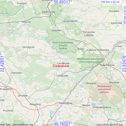
Cieszanów GPS coordinates[2]
50° 14' 44.304" North, 23° 7' 53.868" East
| Map corner | latitude | longitude |
|---|---|---|
| Upper-left | 50.69317°, | 22.42851° |
| Center: | 50.24564°, | 23.13163° |
| Lower-right: | 49.79387°, | 23.83476° |
| Map W x H: | 100×100 km | = 62.1×62.1mi |
| max Lat: | 54.83135° ⇑73.2% North |
| Cieszanów: | 50.24564° |
| min Lat: | ⇓26.8% South 49.21328° |
| min Long | Cieszanów | max Long |
| 14.20249° | 23.13163° | 24.03723° |
| W 96.9%⇐ | ⇒3.1% E |
Elevation
Elevation of Cieszanów is 217 m = 712 ft, and this is 25.6 m = 84 ft above average elevation for this country.
| Max E: |
974 m = 3196 ft | 33.8% |
| Cieszanów | 217 m 712 ft | |
| Avg. | 191.4 m = 628 ft | |
Min E: |
-3 m = -10 ft | 66.2% |
See also: Poland elevation on elevation.city.
Geographical zone
Cieszanów is located in North temperate zone (between Tropic of Cancer and the Arctic Circle). Distance of this North polar circle is 1814.4 km =1127.4 mi to North.| Distance of | km | miles | from Cieszanów |
|---|---|---|---|
| North Pole | 4420.3 | 2746.6 | to North |
| Arctic Circle | 1814.4 | 1127.4 | to North |
| Tropic Cancer | 2980.9 | 1852.2 | to South |
| Equator | 5586.8 | 3471.5 | to South |


Nearby cities:
15 places around Cieszanów: (largest is in red/bold)
• Babice
20.2 km =12.6 mi,  306°
306°
• Chotylub
6.8 km =4.2 mi,  97°
97°
• Dzików Stary
14.3 km =8.9 mi,  270°
270°
• Horyniec-Zdrój
17.5 km =10.9 mi,  110°
110°
• Lubaczów
9.9 km =6.2 mi,  183°
183°
• Narol
18 km =11.2 mi,  50°
50°
• Nowe Brusno
13.3 km =8.3 mi,  90°
90°
• Nowe Sioło
2.5 km =1.6 mi,  128°
128°
• Obsza
14.6 km =9.1 mi,  301°
301°
• Oleszyce
11.1 km =6.9 mi,  218°
218°
• Oseredek
20.4 km =12.7 mi,  6°
6°
• Susiec
19.9 km =12.4 mi, 13°
• Wielkie Oczy
24.8 km =15.4 mi,  174°
174°
• Zamch
10.8 km =6.7 mi,  317°
317°
• Łukowa
19.6 km =12.2 mi, 316°
Sources, notices
• [Note1] Compared only with cities in Poland existing in our database
• [Src1] Map data: © OpenStreetMap contributors (CC-BY-SA)
• [Src2] Other city data from geonames.org with taken over terms of usage.
• [Src3] Geographical zone / Annual Mean Temperature by Robert A. Rohde @ Wikipedia
