Narol geodata
Narol (Subcarpathian) is a seat of a third-order administrative division; located in Poland in Europe/Warsaw (GMT+2) time zone. With population of 2,098 people, there are 1427 cities with bigger population in this country. Compared to other cities in Poland, 70.8% of cities are located further ↑North; 97.9% of cities are located further ←West and 81.2% of cities have lower elevation than Narol. Note1


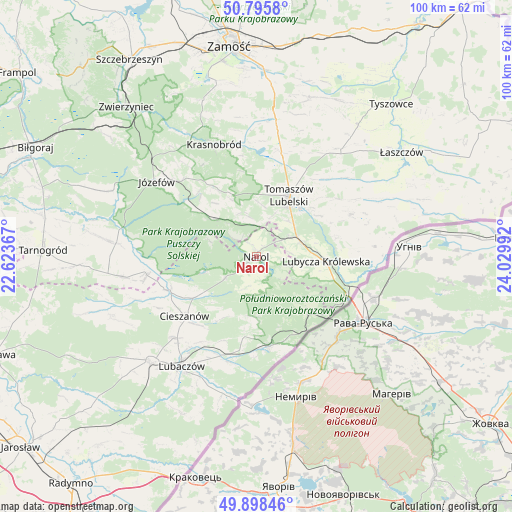
Narol GPS coordinates[2]
50° 20' 57.3" North, 23° 19' 36.444" East
| Map corner | latitude | longitude |
|---|---|---|
| Upper-left | 50.7958°, | 22.62367° |
| Center: | 50.34925°, | 23.32679° |
| Lower-right: | 49.89846°, | 24.02992° |
| Map W x H: | 99.8×99.8 km | = 62×62mi |
| max Lat: | 54.83135° ⇑70.8% North |
| Narol: | 50.34925° |
| min Lat: | ⇓29.2% South 49.21328° |
| min Long | Narol | max Long |
| 14.20249° | 23.32679° | 24.03723° |
| W 97.9%⇐ | ⇒2.1% E |
Elevation
Elevation of Narol is 271 m = 889 ft, and this is 79.6 m = 261 ft above average elevation for this country.
| Max E: |
974 m = 3196 ft | 18.8% |
| Narol | 271 m 889 ft | |
| Avg. | 191.4 m = 628 ft | |
Min E: |
-3 m = -10 ft | 81.2% |
See also: Poland elevation on elevation.city.
Geographical zone
Narol is located in North temperate zone (between Tropic of Cancer and the Arctic Circle). Distance of this North polar circle is 1802.9 km =1120.3 mi to North.| Distance of | km | miles | from Narol |
|---|---|---|---|
| North Pole | 4408.8 | 2739.5 | to North |
| Arctic Circle | 1802.9 | 1120.3 | to North |
| Tropic Cancer | 2992.4 | 1859.4 | to South |
| Equator | 5598.3 | 3478.6 | to South |


Nearby cities:
15 places around Narol: (largest is in red/bold)
• Bełżec
8.8 km =5.5 mi,  63°
63°
• Chotylub
14.3 km =8.9 mi,  209°
209°
• Cieszanów
18 km =11.2 mi,  230°
230°
• Horyniec-Zdrój
17.7 km =11 mi,  171°
171°
• Jarczów
20.2 km =12.6 mi,  65°
65°
• Lubycza Królewska
13.7 km =8.5 mi,  93°
93°
• Nowe Brusno
11.6 km =7.2 mi,  182°
182°
• Nowe Sioło
17.7 km =11 mi,  222°
222°
• Oseredek
14.6 km =9.1 mi,  306°
306°
• Rogóźno
13.5 km =8.4 mi,  19°
19°
• Stanisławów
22.2 km =13.8 mi,  323°
323°
• Susiec
12.1 km =7.5 mi, 310°
• Tarnawatka
20.9 km =13 mi,  13°
13°
• Tomaszów Lubelski
12.6 km =7.8 mi,  30°
30°
• Zamch
21.5 km =13.4 mi,  260°
260°
Sources, notices
• [Note1] Compared only with cities in Poland existing in our database
• [Src1] Map data: © OpenStreetMap contributors (CC-BY-SA)
• [Src2] Other city data from geonames.org with taken over terms of usage.
• [Src3] Geographical zone / Annual Mean Temperature by Robert A. Rohde @ Wikipedia
