Łukowa geodata
Łukowa (Lublin) is a seat of a third-order administrative division; located in Poland in Europe/Warsaw (GMT+2) time zone. With population of 2,604 people, there are 1203 cities with bigger population in this country. Compared to other cities in Poland, 70.2% of cities are located further ↑North; 95.6% of cities are located further ←West and 59.4% of cities have lower elevation than Łukowa. Note1


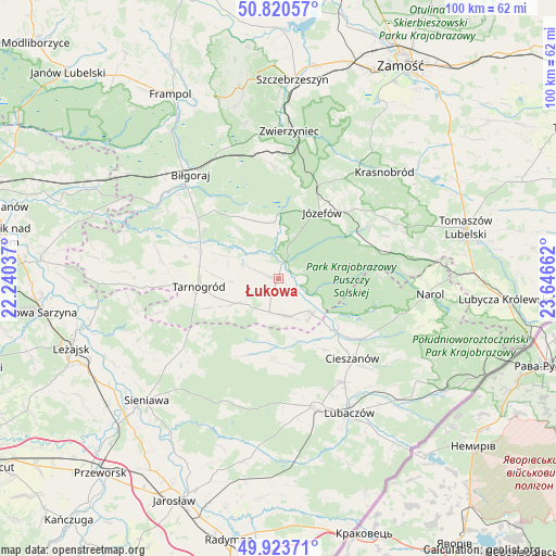
Łukowa GPS coordinates[2]
50° 22' 27.336" North, 22° 56' 36.564" East
| Map corner | latitude | longitude |
|---|---|---|
| Upper-left | 50.82057°, | 22.24037° |
| Center: | 50.37426°, | 22.94349° |
| Lower-right: | 49.92371°, | 23.64662° |
| Map W x H: | 99.7×99.7 km | = 62×62mi |
| max Lat: | 54.83135° ⇑70.2% North |
| Łukowa: | 50.37426° |
| min Lat: | ⇓29.8% South 49.21328° |
| min Long | Łukowa | max Long |
| 14.20249° | 22.94349° | 24.03723° |
| W 95.6%⇐ | ⇒4.4% E |
Elevation
Elevation of Łukowa is 199 m = 653 ft, and this is 7.6 m = 25 ft above average elevation for this country.
| Max E: |
974 m = 3196 ft | 40.6% |
| Łukowa | 199 m 653 ft | |
| Avg. | 191.4 m = 628 ft | |
Min E: |
-3 m = -10 ft | 59.4% |
See also: Poland elevation on elevation.city.
Geographical zone
Łukowa is located in North temperate zone (between Tropic of Cancer and the Arctic Circle). Distance of this North polar circle is 1800.1 km =1118.5 mi to North.| Distance of | km | miles | from Łukowa |
|---|---|---|---|
| North Pole | 4406 | 2737.8 | to North |
| Arctic Circle | 1800.1 | 1118.5 | to North |
| Tropic Cancer | 2995.2 | 1861.1 | to South |
| Equator | 5601.1 | 3480.4 | to South |


Nearby cities:
15 places around Łukowa: (largest is in red/bold)
• Adamówka
21.8 km =13.5 mi,  233°
233°
• Aleksandrów
10.9 km =6.8 mi,  340°
340°
• Babice
3.8 km =2.4 mi, 230°
• Biszcza
21 km =13 mi,  278°
278°
• Cieszanów
19.6 km =12.2 mi,  136°
136°
• Dzików Stary
14.2 km =8.8 mi,  183°
183°
• Józefów
14.2 km =8.8 mi,  33°
33°
• Księżpol
15.7 km =9.8 mi,  290°
290°
• Nowe Sioło
22 km =13.7 mi, 135°
• Obsza
6.6 km =4.1 mi,  171°
171°
• Oseredek
16.6 km =10.3 mi,  68°
68°
• Stanisławów
20.4 km =12.7 mi,  42°
42°
• Susiec
18.6 km =11.6 mi, 74°
• Tarnogród
14.4 km =8.9 mi,  264°
264°
• Zamch
8.7 km =5.4 mi, 136°
Sources, notices
• [Note1] Compared only with cities in Poland existing in our database
• [Src1] Map data: © OpenStreetMap contributors (CC-BY-SA)
• [Src2] Other city data from geonames.org with taken over terms of usage.
• [Src3] Geographical zone / Annual Mean Temperature by Robert A. Rohde @ Wikipedia
