Zamch geodata
Zamch (Lublin) is a populated place; located in Poland in Europe/Warsaw (GMT+2) time zone. With population of 1,500 people, there are 1837 cities with bigger population in this country. Compared to other cities in Poland, 71.6% of cities are located further ↑North; 96.3% of cities are located further ←West and 61% of cities have lower elevation than Zamch. Note1


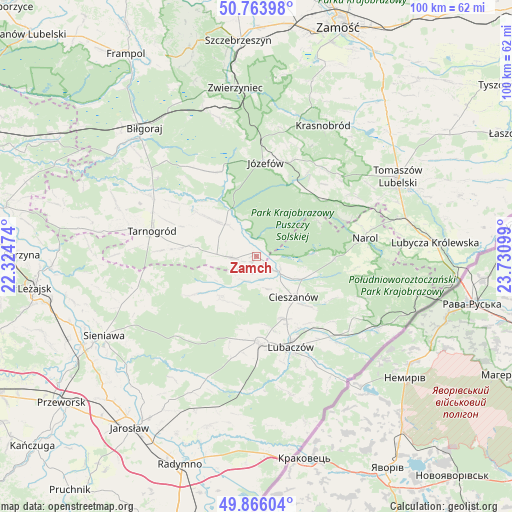
Zamch GPS coordinates[2]
50° 19' 1.668" North, 23° 1' 40.296" East
| Map corner | latitude | longitude |
|---|---|---|
| Upper-left | 50.76398°, | 22.32474° |
| Center: | 50.31713°, | 23.02786° |
| Lower-right: | 49.86604°, | 23.73099° |
| Map W x H: | 99.8×99.8 km | = 62×62mi |
| max Lat: | 54.83135° ⇑71.6% North |
| Zamch: | 50.31713° |
| min Lat: | ⇓28.4% South 49.21328° |
| min Long | Zamch | max Long |
| 14.20249° | 23.02786° | 24.03723° |
| W 96.3%⇐ | ⇒3.7% E |
Elevation
Elevation of Zamch is 203 m = 666 ft, and this is 11.6 m = 38 ft above average elevation for this country.
| Max E: |
974 m = 3196 ft | 39% |
| Zamch | 203 m 666 ft | |
| Avg. | 191.4 m = 628 ft | |
Min E: |
-3 m = -10 ft | 61% |
See also: Poland elevation on elevation.city.
Geographical zone
Zamch is located in North temperate zone (between Tropic of Cancer and the Arctic Circle). Distance of this North polar circle is 1806.4 km =1122.4 mi to North.| Distance of | km | miles | from Zamch |
|---|---|---|---|
| North Pole | 4412.3 | 2741.7 | to North |
| Arctic Circle | 1806.4 | 1122.4 | to North |
| Tropic Cancer | 2988.8 | 1857.2 | to South |
| Equator | 5594.7 | 3476.4 | to South |


Nearby cities:
15 places around Zamch: (largest is in red/bold)
• Aleksandrów
19.2 km =11.9 mi,  329°
329°
• Babice
9.8 km =6.1 mi,  293°
293°
• Chotylub
16.6 km =10.3 mi,  121°
121°
• Cieszanów
10.8 km =6.7 mi,  137°
137°
• Dzików Stary
10.5 km =6.5 mi,  221°
221°
• Józefów
18.3 km =11.4 mi,  5°
5°
• Lubaczów
19.1 km =11.9 mi,  159°
159°
• Narol
21.5 km =13.4 mi,  80°
80°
• Nowe Sioło
13.3 km =8.3 mi, 135°
• Obsza
5 km =3.1 mi,  267°
267°
• Oleszyce
16.6 km =10.3 mi,  178°
178°
• Oseredek
15.6 km =9.7 mi,  37°
37°
• Susiec
16.5 km =10.3 mi,  46°
46°
• Tarnogród
20.9 km =13 mi,  283°
283°
• Łukowa
8.7 km =5.4 mi,  316°
316°
Sources, notices
• [Note1] Compared only with cities in Poland existing in our database
• [Src1] Map data: © OpenStreetMap contributors (CC-BY-SA)
• [Src2] Other city data from geonames.org with taken over terms of usage.
• [Src3] Geographical zone / Annual Mean Temperature by Robert A. Rohde @ Wikipedia
