Bufalo geodata
Bufalo (Barceloneta) is a populated place; located in Puerto Rico in America/Puerto_Rico (GMT-4) time zone. With population of 1,108 people, there are 211 cities with bigger population in this country. Compared to other cities in Puerto Rico, 80% of cities are located further ↓South; 67.6% of cities are located further →East and 76% of cities have lower elevation than Bufalo. Note1


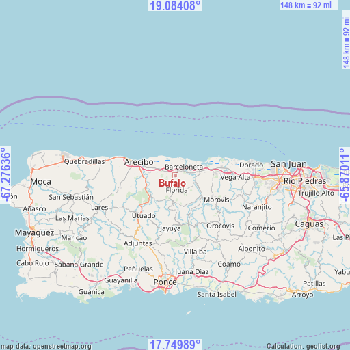
Bufalo GPS coordinates[2]
18° 25' 5.808" North, 66° 34' 23.628" West
| Map corner | latitude | longitude |
|---|---|---|
| Upper-left | 19.08408°, | -67.27636° |
| Center: | 18.41828°, | -66.57323° |
| Lower-right: | 17.74989°, | -65.87011° |
| Map W x H: | 148.3×148.4 km | = 92.1×92.2mi |
| max Lat: | 18.50078° ⇑20% North |
| Bufalo: | 18.41828° |
| min Lat: | ⇓80% South 17.95358° |
| min Long | Bufalo | max Long |
| -67.2499° | -66.57323° | -65.30099° |
| W 32.4%⇐ | ⇒67.6% E |
Elevation
Elevation of Bufalo is 135 m = 443 ft, and this is 34.5 m = 113 ft above average elevation for this country.
| Max E: |
655 m = 2149 ft | 24% |
| Bufalo | 135 m 443 ft | |
| Avg. | 100.5 m = 330 ft | |
Min E: |
1 m = 3 ft | 76% |
See also: Puerto Rico elevation on elevation.city.
Geographical zone
Bufalo is located in North Torrid zone (between Equator and Tropic of Cancer). Distance of this Northern Tropic circle is 558 km =346.7 mi to North.| Distance of | km | miles | from Bufalo |
|---|---|---|---|
| North Pole | 7959.1 | 4945.6 | to North |
| Arctic Circle | 5353.3 | 3326.4 | to North |
| Tropic Cancer | 558 | 346.7 | to North |
| Equator | 2047.9 | 1272.5 | to South |


Nearby cities:
15 places around Bufalo: (largest is in red/bold)
• Animas
7.2 km =4.5 mi,  294°
294°
• Bajadero
11.6 km =7.2 mi,  274°
274°
• Barceloneta
5.1 km =3.2 mi,  45°
45°
• Coto Norte
14.1 km =8.8 mi,  84°
84°
• Estancias de Florida
5.8 km =3.6 mi,  176°
176°
• Florida
6.3 km =3.9 mi,  168°
168°
• Garrochales
4 km =2.5 mi,  10°
10°
• Imbery
3 km =1.9 mi, 46°
• La Alianza
3.9 km =2.4 mi,  233°
233°
• La Luisa
7.5 km =4.7 mi,  63°
63°
• Manatí
8.6 km =5.3 mi, 83°
• Pajonal
4.4 km =2.7 mi,  155°
155°
• Sabana Hoyos
4.6 km =2.9 mi, 292°
• Tiburones
1.7 km =1.1 mi,  331°
331°
• Tierras Nuevas Poniente
10.2 km =6.3 mi, 61°
Sources, notices
• [Note1] Compared only with cities in Puerto Rico existing in our database
• [Src1] Map data: © OpenStreetMap contributors (CC-BY-SA)
• [Src2] Other city data from geonames.org with taken over terms of usage.
• [Src3] Geographical zone / Annual Mean Temperature by Robert A. Rohde @ Wikipedia
