Coto Laurel geodata
Coto Laurel (Ponce) is a populated place; located in Puerto Rico in America/Puerto_Rico (GMT-4) time zone. With population of 3,606 people, there are 88 cities with bigger population in this country. Compared to other cities in Puerto Rico, 77.8% of cities are located further ↑North; 64.9% of cities are located further →East and 60.9% of cities have lower elevation than Coto Laurel. Note1


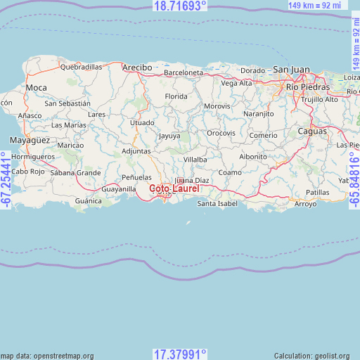
Coto Laurel GPS coordinates[2]
18° 2' 58.884" North, 66° 33' 4.608" West
| Map corner | latitude | longitude |
|---|---|---|
| Upper-left | 18.71693°, | -67.25441° |
| Center: | 18.04969°, | -66.55128° |
| Lower-right: | 17.37991°, | -65.84816° |
| Map W x H: | 148.7×148.7 km | = 92.4×92.4mi |
| max Lat: | 18.50078° ⇑77.8% North |
| Coto Laurel: | 18.04969° |
| min Lat: | ⇓22.2% South 17.95358° |
| min Long | Coto Laurel | max Long |
| -67.2499° | -66.55128° | -65.30099° |
| W 35.1%⇐ | ⇒64.9% E |
Elevation
Elevation of Coto Laurel is 71 m = 233 ft, and this is 29.5 m = 97 ft below average elevation for this country.
| Max E: |
655 m = 2149 ft | 39.1% |
| Avg. | 100.5 m = 330 ft | |
| Coto Laurel | 71 m = 233 ft | |
Min E: |
1 m = 3 ft | 60.9% |
See also: Puerto Rico elevation on elevation.city.
Geographical zone
Coto Laurel is located in North Torrid zone (between Equator and Tropic of Cancer). Distance of this Northern Tropic circle is 599 km =372.2 mi to North.| Distance of | km | miles | from Coto Laurel |
|---|---|---|---|
| North Pole | 8000.1 | 4971 | to North |
| Arctic Circle | 5394.2 | 3351.8 | to North |
| Tropic Cancer | 599 | 372.2 | to North |
| Equator | 2006.9 | 1247 | to South |


Nearby cities:
15 places around Coto Laurel: (largest is in red/bold)
• Aguilita
3.4 km =2.1 mi,  149°
149°
• Capitanejo
4.3 km =2.7 mi, 154°
• El Ojo
17.6 km =10.9 mi,  106°
106°
• Guayabal
6.4 km =4 mi,  56°
56°
• Juana Díaz
4.7 km =2.9 mi,  86°
86°
• Las Ollas
13.5 km =8.4 mi,  97°
97°
• Los Llanos
15.4 km =9.6 mi, 87°
• Luis Llorens Torres
2.7 km =1.7 mi,  72°
72°
• Marueño
11.1 km =6.9 mi,  274°
274°
• Playita Cortada
13.9 km =8.6 mi,  121°
121°
• Ponce
8.8 km =5.5 mi,  240°
240°
• Potala Pastillo
8.7 km =5.4 mi,  138°
138°
• Río Cañas Abajo
8.9 km =5.5 mi, 98°
• Tallaboa Alta
15.7 km =9.8 mi, 270°
• Villalba
10.6 km =6.6 mi,  35°
35°
Sources, notices
• [Note1] Compared only with cities in Puerto Rico existing in our database
• [Src1] Map data: © OpenStreetMap contributors (CC-BY-SA)
• [Src2] Other city data from geonames.org with taken over terms of usage.
• [Src3] Geographical zone / Annual Mean Temperature by Robert A. Rohde @ Wikipedia
