Las Ollas geodata
Las Ollas (Santa Isabel) is a populated place; located in Puerto Rico in America/Puerto_Rico (GMT-4) time zone. With population of 1,949 people, there are 145 cities with bigger population in this country. Compared to other cities in Puerto Rico, 81.8% of cities are located further ↑North; 56.9% of cities are located further →East and 56.4% of cities have lower elevation than Las Ollas. Note1


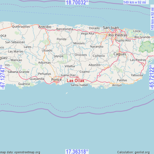
Las Ollas GPS coordinates[2]
18° 1' 58.872" North, 66° 25' 27.624" West
| Map corner | latitude | longitude |
|---|---|---|
| Upper-left | 18.70032°, | -67.12747° |
| Center: | 18.03302°, | -66.42434° |
| Lower-right: | 17.36318°, | -65.72122° |
| Map W x H: | 148.7×148.7 km | = 92.4×92.4mi |
| max Lat: | 18.50078° ⇑81.8% North |
| Las Ollas: | 18.03302° |
| min Lat: | ⇓18.2% South 17.95358° |
| min Long | Las Ollas | max Long |
| -67.2499° | -66.42434° | -65.30099° |
| W 43.1%⇐ | ⇒56.9% E |
Elevation
Elevation of Las Ollas is 64 m = 210 ft, and this is 36.5 m = 120 ft below average elevation for this country.
| Max E: |
655 m = 2149 ft | 43.6% |
| Avg. | 100.5 m = 330 ft | |
| Las Ollas | 64 m = 210 ft | |
Min E: |
1 m = 3 ft | 56.4% |
See also: Puerto Rico elevation on elevation.city.
Geographical zone
Las Ollas is located in North Torrid zone (between Equator and Tropic of Cancer). Distance of this Northern Tropic circle is 600.8 km =373.3 mi to North.| Distance of | km | miles | from Las Ollas |
|---|---|---|---|
| North Pole | 8002 | 4972.2 | to North |
| Arctic Circle | 5396.1 | 3353 | to North |
| Tropic Cancer | 600.8 | 373.3 | to North |
| Equator | 2005.1 | 1245.9 | to South |


Nearby cities:
15 places around Las Ollas: (largest is in red/bold)
• Capitanejo
11.7 km =7.3 mi,  259°
259°
• Coamo
8.7 km =5.4 mi,  53°
53°
• El Ojo
4.7 km =2.9 mi,  133°
133°
• Guayabal
9.7 km =6 mi,  303°
303°
• Jauca
9.4 km =5.8 mi,  138°
138°
• Juana Díaz
9 km =5.6 mi,  283°
283°
• Los Llanos
3.2 km =2 mi,  38°
38°
• Luis Llorens Torres
11.2 km =7 mi, 283°
• Mariano Colón
9.8 km =6.1 mi,  96°
96°
• Palmarejo
11.2 km =7 mi,  69°
69°
• Parcelas Peñuelas
9.6 km =6 mi,  113°
113°
• Playita Cortada
5.6 km =3.5 mi,  196°
196°
• Potala Pastillo
8.9 km =5.5 mi,  238°
238°
• Río Cañas Abajo
4.6 km =2.9 mi, 277°
• Santa Isabel
7.7 km =4.8 mi,  164°
164°
Sources, notices
• [Note1] Compared only with cities in Puerto Rico existing in our database
• [Src1] Map data: © OpenStreetMap contributors (CC-BY-SA)
• [Src2] Other city data from geonames.org with taken over terms of usage.
• [Src3] Geographical zone / Annual Mean Temperature by Robert A. Rohde @ Wikipedia
