Villalba geodata
Villalba is a seat of a first-order administrative division; located in Puerto Rico in America/Puerto_Rico (GMT-4) time zone. With population of 4,555 people, there are 76 cities with bigger population in this country. Compared to other cities in Puerto Rico, 65.8% of cities are located further ↑North; 60.9% of cities are located further →East and 80.9% of cities have lower elevation than Villalba. Note1


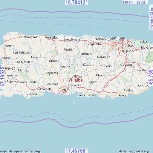
Villalba GPS coordinates[2]
18° 7' 37.848" North, 66° 29' 31.632" West
| Map corner | latitude | longitude |
|---|---|---|
| Upper-left | 18.79412°, | -67.19525° |
| Center: | 18.12718°, | -66.49212° |
| Lower-right: | 17.45769°, | -65.789° |
| Map W x H: | 148.6×148.6 km | = 92.3×92.3mi |
| max Lat: | 18.50078° ⇑65.8% North |
| Villalba: | 18.12718° |
| min Lat: | ⇓34.2% South 17.95358° |
| min Long | Villalba | max Long |
| -67.2499° | -66.49212° | -65.30099° |
| W 39.1%⇐ | ⇒60.9% E |
Elevation
Elevation of Villalba is 159 m = 522 ft, and this is 58.5 m = 192 ft above average elevation for this country.
| Max E: |
655 m = 2149 ft | 19.1% |
| Villalba | 159 m 522 ft | |
| Avg. | 100.5 m = 330 ft | |
Min E: |
1 m = 3 ft | 80.9% |
See also: Puerto Rico elevation on elevation.city.
Geographical zone
Villalba is located in North Torrid zone (between Equator and Tropic of Cancer). Distance of this Northern Tropic circle is 590.4 km =366.9 mi to North.| Distance of | km | miles | from Villalba |
|---|---|---|---|
| North Pole | 7991.5 | 4965.7 | to North |
| Arctic Circle | 5385.6 | 3346.5 | to North |
| Tropic Cancer | 590.4 | 366.9 | to North |
| Equator | 2015.6 | 1252.4 | to South |


Nearby cities:
15 places around Villalba: (largest is in red/bold)
• Aguilita
12.4 km =7.7 mi,  201°
201°
• Capitanejo
13.3 km =8.3 mi, 199°
• Coamo
15.1 km =9.4 mi,  110°
110°
• Coto Laurel
10.6 km =6.6 mi,  215°
215°
• El Ojo
17.4 km =10.8 mi,  142°
142°
• Guayabal
5.2 km =3.2 mi,  190°
190°
• Jayuya
14.6 km =9.1 mi,  314°
314°
• Juana Díaz
8.4 km =5.2 mi, 190°
• Las Ollas
12.7 km =7.9 mi,  145°
145°
• Los Llanos
12.1 km =7.5 mi,  131°
131°
• Luis Llorens Torres
8.6 km =5.3 mi,  205°
205°
• Orocovis
15.4 km =9.6 mi,  43°
43°
• Playita Cortada
16.8 km =10.4 mi,  160°
160°
• Potala Pastillo
15.1 km =9.4 mi,  181°
181°
• Río Cañas Abajo
10.2 km =6.3 mi,  165°
165°
Sources, notices
• [Note1] Compared only with cities in Puerto Rico existing in our database
• [Src1] Map data: © OpenStreetMap contributors (CC-BY-SA)
• [Src2] Other city data from geonames.org with taken over terms of usage.
• [Src3] Geographical zone / Annual Mean Temperature by Robert A. Rohde @ Wikipedia
