Guayabal geodata
Guayabal (Juana Díaz) is a populated place; located in Puerto Rico in America/Puerto_Rico (GMT-4) time zone. With population of 2,377 people, there are 118 cities with bigger population in this country. Compared to other cities in Puerto Rico, 70.2% of cities are located further ↑North; 61.8% of cities are located further →East and 64.4% of cities have lower elevation than Guayabal. Note1


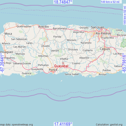
Guayabal GPS coordinates[2]
18° 4' 52.86" North, 66° 30' 4.608" West
| Map corner | latitude | longitude |
|---|---|---|
| Upper-left | 18.74847°, | -67.20441° |
| Center: | 18.08135°, | -66.50128° |
| Lower-right: | 17.41169°, | -65.79816° |
| Map W x H: | 148.6×148.6 km | = 92.3×92.3mi |
| max Lat: | 18.50078° ⇑70.2% North |
| Guayabal: | 18.08135° |
| min Lat: | ⇓29.8% South 17.95358° |
| min Long | Guayabal | max Long |
| -67.2499° | -66.50128° | -65.30099° |
| W 38.2%⇐ | ⇒61.8% E |
Elevation
Elevation of Guayabal is 79 m = 259 ft, and this is 21.5 m = 71 ft below average elevation for this country.
| Max E: |
655 m = 2149 ft | 35.6% |
| Avg. | 100.5 m = 330 ft | |
| Guayabal | 79 m = 259 ft | |
Min E: |
1 m = 3 ft | 64.4% |
See also: Puerto Rico elevation on elevation.city.
Geographical zone
Guayabal is located in North Torrid zone (between Equator and Tropic of Cancer). Distance of this Northern Tropic circle is 595.5 km =370 mi to North.| Distance of | km | miles | from Guayabal |
|---|---|---|---|
| North Pole | 7996.6 | 4968.9 | to North |
| Arctic Circle | 5390.7 | 3349.6 | to North |
| Tropic Cancer | 595.5 | 370 | to North |
| Equator | 2010.5 | 1249.3 | to South |


Nearby cities:
15 places around Guayabal: (largest is in red/bold)
• Aguilita
7.4 km =4.6 mi,  208°
208°
• Capitanejo
8.2 km =5.1 mi,  204°
204°
• Coamo
15.2 km =9.4 mi,  90°
90°
• Coto Laurel
6.4 km =4 mi,  236°
236°
• El Ojo
14.5 km =9 mi,  126°
126°
• Juana Díaz
3.3 km =2.1 mi,  189°
189°
• Las Ollas
9.7 km =6 mi,  123°
123°
• Los Llanos
10.5 km =6.5 mi,  106°
106°
• Luis Llorens Torres
3.8 km =2.4 mi,  224°
224°
• Playita Cortada
12.6 km =7.8 mi,  148°
148°
• Ponce
15.2 km =9.4 mi, 238°
• Potala Pastillo
10 km =6.2 mi,  177°
177°
• Río Cañas Abajo
6 km =3.7 mi,  143°
143°
• Santa Isabel
16.4 km =10.2 mi, 141°
• Villalba
5.2 km =3.2 mi,  10°
10°
Sources, notices
• [Note1] Compared only with cities in Puerto Rico existing in our database
• [Src1] Map data: © OpenStreetMap contributors (CC-BY-SA)
• [Src2] Other city data from geonames.org with taken over terms of usage.
• [Src3] Geographical zone / Annual Mean Temperature by Robert A. Rohde @ Wikipedia
