Jauca geodata
Jauca (Santa Isabel) is a populated place; located in Puerto Rico in America/Puerto_Rico (GMT-4) time zone. With population of 1,838 people, there are 152 cities with bigger population in this country. Compared to other cities in Puerto Rico, 97.8% of cities are located further ↑North; 53.3% of cities are located further →East and 99.6% of cities have higher elevation than Jauca. Note1


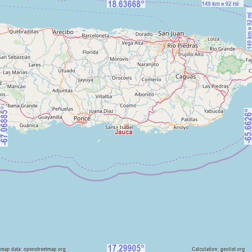
Jauca GPS coordinates[2]
17° 58' 8.868" North, 66° 21' 56.592" West
| Map corner | latitude | longitude |
|---|---|---|
| Upper-left | 18.63668°, | -67.06885° |
| Center: | 17.96913°, | -66.36572° |
| Lower-right: | 17.29905°, | -65.6626° |
| Map W x H: | 148.7×148.7 km | = 92.4×92.4mi |
| max Lat: | 18.50078° ⇑97.8% North |
| Jauca: | 17.96913° |
| min Lat: | ⇓2.2% South 17.95358° |
| min Long | Jauca | max Long |
| -67.2499° | -66.36572° | -65.30099° |
| W 46.7%⇐ | ⇒53.3% E |
Elevation
Elevation of Jauca is 2 m = 7 ft, and this is 98.5 m = 323 ft below average elevation for this country.
| Max E: |
655 m = 2149 ft | 99.6% |
| Avg. | 100.5 m = 330 ft | |
| Jauca | 2 m = 7 ft | |
Min E: |
1 m = 3 ft | 0.4% |
See also: Puerto Rico elevation on elevation.city.
Geographical zone
Jauca is located in North Torrid zone (between Equator and Tropic of Cancer). Distance of this Northern Tropic circle is 607.9 km =377.7 mi to North.| Distance of | km | miles | from Jauca |
|---|---|---|---|
| North Pole | 8009.1 | 4976.6 | to North |
| Arctic Circle | 5403.2 | 3357.4 | to North |
| Tropic Cancer | 607.9 | 377.7 | to North |
| Equator | 1998 | 1241.5 | to South |


Nearby cities:
15 places around Jauca: (largest is in red/bold)
• Coamo
12.4 km =7.7 mi,  3°
3°
• Coco
12 km =7.5 mi,  69°
69°
• El Ojo
4.7 km =2.9 mi,  324°
324°
• Las Ochenta
5.3 km =3.3 mi, 71°
• Las Ollas
9.4 km =5.8 mi, 318°
• Los Llanos
10.5 km =6.5 mi,  336°
336°
• Mariano Colón
7 km =4.3 mi,  30°
30°
• Palmarejo
11.8 km =7.3 mi,  21°
21°
• Parcelas Peñuelas
4.2 km =2.6 mi,  38°
38°
• Playita
8.1 km =5 mi,  96°
96°
• Playita Cortada
8 km =5 mi,  282°
282°
• Potala Pastillo
14.1 km =8.8 mi, 280°
• Río Cañas Abajo
13.2 km =8.2 mi,  305°
305°
• Salinas
7.2 km =4.5 mi,  82°
82°
• Santa Isabel
4.2 km =2.6 mi,  265°
265°
Sources, notices
• [Note1] Compared only with cities in Puerto Rico existing in our database
• [Src1] Map data: © OpenStreetMap contributors (CC-BY-SA)
• [Src2] Other city data from geonames.org with taken over terms of usage.
• [Src3] Geographical zone / Annual Mean Temperature by Robert A. Rohde @ Wikipedia
