Palmarejo geodata
Palmarejo (Coamo) is a populated place; located in Puerto Rico in America/Puerto_Rico (GMT-4) time zone. With population of 1,087 people, there are 213 cities with bigger population in this country. Compared to other cities in Puerto Rico, 72.4% of cities are located further ↑North; 50.7% of cities are located further ←West and 88.9% of cities have lower elevation than Palmarejo. Note1


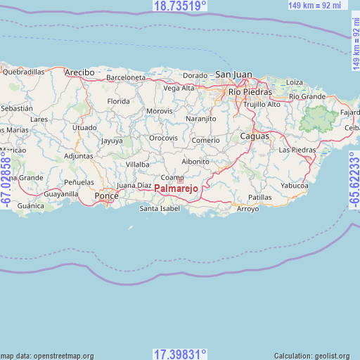
Palmarejo GPS coordinates[2]
18° 4' 4.872" North, 66° 19' 31.62" West
| Map corner | latitude | longitude |
|---|---|---|
| Upper-left | 18.73519°, | -67.02858° |
| Center: | 18.06802°, | -66.32545° |
| Lower-right: | 17.39831°, | -65.62233° |
| Map W x H: | 148.6×148.6 km | = 92.3×92.3mi |
| max Lat: | 18.50078° ⇑72.4% North |
| Palmarejo: | 18.06802° |
| min Lat: | ⇓27.6% South 17.95358° |
| min Long | Palmarejo | max Long |
| -67.2499° | -66.32545° | -65.30099° |
| W 50.7%⇐ | ⇒49.3% E |
Elevation
Elevation of Palmarejo is 241 m = 791 ft, and this is 140.5 m = 461 ft above average elevation for this country.
| Max E: |
655 m = 2149 ft | 11.1% |
| Palmarejo | 241 m 791 ft | |
| Avg. | 100.5 m = 330 ft | |
Min E: |
1 m = 3 ft | 88.9% |
See also: Puerto Rico elevation on elevation.city.
Geographical zone
Palmarejo is located in North Torrid zone (between Equator and Tropic of Cancer). Distance of this Northern Tropic circle is 596.9 km =370.9 mi to North.| Distance of | km | miles | from Palmarejo |
|---|---|---|---|
| North Pole | 7998.1 | 4969.8 | to North |
| Arctic Circle | 5392.2 | 3350.6 | to North |
| Tropic Cancer | 596.9 | 370.9 | to North |
| Equator | 2009 | 1248.3 | to South |


Nearby cities:
15 places around Palmarejo: (largest is in red/bold)
• Aibonito
10.2 km =6.3 mi,  38°
38°
• Coamo
3.7 km =2.3 mi,  291°
291°
• Coco
9.7 km =6 mi,  134°
134°
• El Ojo
10 km =6.2 mi,  224°
224°
• Jauca
11.8 km =7.3 mi,  201°
201°
• La Plena
13 km =8.1 mi,  100°
100°
• Las Ochenta
9.3 km =5.8 mi,  175°
175°
• Las Ollas
11.2 km =7 mi,  249°
249°
• Los Llanos
8.6 km =5.3 mi,  260°
260°
• Mariano Colón
5 km =3.1 mi,  188°
188°
• Parcelas Peñuelas
7.9 km =4.9 mi, 192°
• Pastos
9 km =5.6 mi,  51°
51°
• Playita
12.5 km =7.8 mi,  162°
162°
• Salinas
10.5 km =6.5 mi, 163°
• Vázquez
9.2 km =5.7 mi,  91°
91°
Sources, notices
• [Note1] Compared only with cities in Puerto Rico existing in our database
• [Src1] Map data: © OpenStreetMap contributors (CC-BY-SA)
• [Src2] Other city data from geonames.org with taken over terms of usage.
• [Src3] Geographical zone / Annual Mean Temperature by Robert A. Rohde @ Wikipedia
