Tallaboa geodata
Tallaboa (Peñuelas) is a populated place; located in Puerto Rico in America/Puerto_Rico (GMT-4) time zone. With population of 1,150 people, there are 204 cities with bigger population in this country. Compared to other cities in Puerto Rico, 90.7% of cities are located further ↑North; 72.9% of cities are located further →East and 69.8% of cities have higher elevation than Tallaboa. Note1


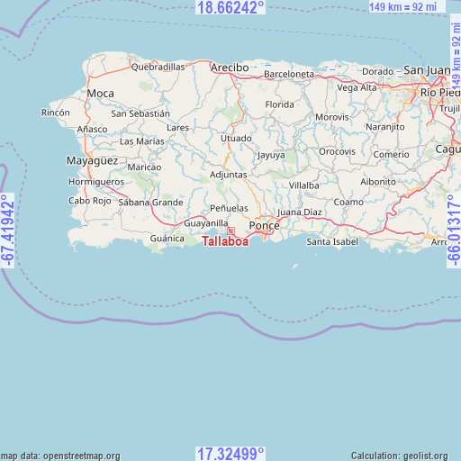
Tallaboa GPS coordinates[2]
17° 59' 41.892" North, 66° 42' 58.644" West
| Map corner | latitude | longitude |
|---|---|---|
| Upper-left | 18.66242°, | -67.41942° |
| Center: | 17.99497°, | -66.71629° |
| Lower-right: | 17.32499°, | -66.01317° |
| Map W x H: | 148.7×148.7 km | = 92.4×92.4mi |
| max Lat: | 18.50078° ⇑90.7% North |
| Tallaboa: | 17.99497° |
| min Lat: | ⇓9.3% South 17.95358° |
| min Long | Tallaboa | max Long |
| -67.2499° | -66.71629° | -65.30099° |
| W 27.1%⇐ | ⇒72.9% E |
Elevation
Elevation of Tallaboa is 21 m = 69 ft, and this is 79.5 m = 261 ft below average elevation for this country.
| Max E: |
655 m = 2149 ft | 69.8% |
| Avg. | 100.5 m = 330 ft | |
| Tallaboa | 21 m = 69 ft | |
Min E: |
1 m = 3 ft | 30.2% |
See also: Puerto Rico elevation on elevation.city.
Geographical zone
Tallaboa is located in North Torrid zone (between Equator and Tropic of Cancer). Distance of this Northern Tropic circle is 605.1 km =376 mi to North.| Distance of | km | miles | from Tallaboa |
|---|---|---|---|
| North Pole | 8006.2 | 4974.8 | to North |
| Arctic Circle | 5400.3 | 3355.6 | to North |
| Tropic Cancer | 605.1 | 376 | to North |
| Equator | 2000.9 | 1243.3 | to South |


Nearby cities:
15 places around Tallaboa: (largest is in red/bold)
• Adjuntas
18.7 km =11.6 mi,  358°
358°
• Aguilita
19.5 km =12.1 mi,  80°
80°
• Capitanejo
19.4 km =12.1 mi, 83°
• Coto Laurel
18.5 km =11.5 mi,  70°
70°
• Guayanilla
8.4 km =5.2 mi,  288°
288°
• Indios
10.9 km =6.8 mi,  269°
269°
• Magas Arriba
6.1 km =3.8 mi, 294°
• Maria Antonia
18.4 km =11.4 mi,  264°
264°
• Marueño
9.4 km =5.8 mi,  42°
42°
• Palomas
16.7 km =10.4 mi,  277°
277°
• Peñuelas
6.8 km =4.2 mi, 355°
• Ponce
9.9 km =6.2 mi, 80°
• Santo Domingo
8.5 km =5.3 mi,  333°
333°
• Tallaboa Alta
6.5 km =4 mi,  15°
15°
• Yauco
14.8 km =9.2 mi, 287°
Sources, notices
• [Note1] Compared only with cities in Puerto Rico existing in our database
• [Src1] Map data: © OpenStreetMap contributors (CC-BY-SA)
• [Src2] Other city data from geonames.org with taken over terms of usage.
• [Src3] Geographical zone / Annual Mean Temperature by Robert A. Rohde @ Wikipedia
