Adjuntas geodata
Adjuntas is a seat of a first-order administrative division; located in Puerto Rico in America/Puerto_Rico (GMT-4) time zone. With population of 5,080 people, there are 69 cities with bigger population in this country. Compared to other cities in Puerto Rico, 61.8% of cities are located further ↑North; 73.8% of cities are located further →East and 97.3% of cities have lower elevation than Adjuntas. Note1


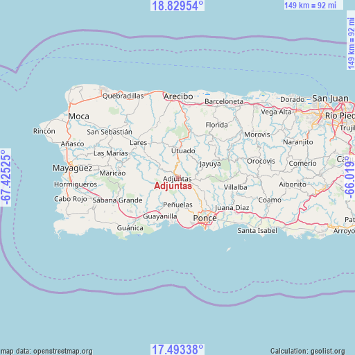
Adjuntas GPS coordinates[2]
18° 9' 45.864" North, 66° 43' 19.632" West
| Map corner | latitude | longitude |
|---|---|---|
| Upper-left | 18.82954°, | -67.42525° |
| Center: | 18.16274°, | -66.72212° |
| Lower-right: | 17.49338°, | -66.019° |
| Map W x H: | 148.6×148.6 km | = 92.3×92.3mi |
| max Lat: | 18.50078° ⇑61.8% North |
| Adjuntas: | 18.16274° |
| min Lat: | ⇓38.2% South 17.95358° |
| min Long | Adjuntas | max Long |
| -67.2499° | -66.72212° | -65.30099° |
| W 26.2%⇐ | ⇒73.8% E |
Elevation
Elevation of Adjuntas is 501 m = 1644 ft, and this is 400.5 m = 1314 ft above average elevation for this country.
| Max E: |
655 m = 2149 ft | 2.7% |
| Adjuntas | 501 m 1644 ft | |
| Avg. | 100.5 m = 330 ft | |
Min E: |
1 m = 3 ft | 97.3% |
See also: Puerto Rico elevation on elevation.city.
Geographical zone
Adjuntas is located in North Torrid zone (between Equator and Tropic of Cancer). Distance of this Northern Tropic circle is 586.4 km =364.4 mi to North.| Distance of | km | miles | from Adjuntas |
|---|---|---|---|
| North Pole | 7987.6 | 4963.3 | to North |
| Arctic Circle | 5381.7 | 3344 | to North |
| Tropic Cancer | 586.4 | 364.4 | to North |
| Equator | 2019.5 | 1254.9 | to South |


Nearby cities:
15 places around Adjuntas: (largest is in red/bold)
• Cayuco
14.4 km =8.9 mi,  352°
352°
• Coto Laurel
22 km =13.7 mi,  124°
124°
• Guayanilla
17.6 km =10.9 mi,  204°
204°
• Indios
21.4 km =13.3 mi,  208°
208°
• Jayuya
15.1 km =9.4 mi,  65°
65°
• Lares
22 km =13.7 mi,  311°
311°
• Magas Arriba
16.9 km =10.5 mi, 197°
• Marueño
13.6 km =8.5 mi,  149°
149°
• Peñuelas
11.8 km =7.3 mi,  179°
179°
• Ponce
19.9 km =12.4 mi, 148°
• Santo Domingo
11.5 km =7.1 mi, 196°
• Tallaboa
18.7 km =11.6 mi, 178°
• Tallaboa Alta
12.6 km =7.8 mi,  169°
169°
• Utuado
11.7 km =7.3 mi,  11°
11°
• Yauco
19.6 km =12.2 mi,  223°
223°
Sources, notices
• [Note1] Compared only with cities in Puerto Rico existing in our database
• [Src1] Map data: © OpenStreetMap contributors (CC-BY-SA)
• [Src2] Other city data from geonames.org with taken over terms of usage.
• [Src3] Geographical zone / Annual Mean Temperature by Robert A. Rohde @ Wikipedia
