Palomas geodata
Palomas (Yauco) is a populated place; located in Puerto Rico in America/Puerto_Rico (GMT-4) time zone. With population of 2,321 people, there are 123 cities with bigger population in this country. Compared to other cities in Puerto Rico, 85.8% of cities are located further ↑North; 80% of cities are located further →East and 51.1% of cities have higher elevation than Palomas. Note1


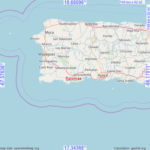
Palomas GPS coordinates[2]
18° 0' 48.888" North, 66° 52' 23.628" West
| Map corner | latitude | longitude |
|---|---|---|
| Upper-left | 18.68096°, | -67.57636° |
| Center: | 18.01358°, | -66.87323° |
| Lower-right: | 17.34366°, | -66.17011° |
| Map W x H: | 148.7×148.7 km | = 92.4×92.4mi |
| max Lat: | 18.50078° ⇑85.8% North |
| Palomas: | 18.01358° |
| min Lat: | ⇓14.2% South 17.95358° |
| min Long | Palomas | max Long |
| -67.2499° | -66.87323° | -65.30099° |
| W 20%⇐ | ⇒80% E |
Elevation
Elevation of Palomas is 44 m = 144 ft, and this is 56.5 m = 185 ft below average elevation for this country.
| Max E: |
655 m = 2149 ft | 51.1% |
| Avg. | 100.5 m = 330 ft | |
| Palomas | 44 m = 144 ft | |
Min E: |
1 m = 3 ft | 48.9% |
See also: Puerto Rico elevation on elevation.city.
Geographical zone
Palomas is located in North Torrid zone (between Equator and Tropic of Cancer). Distance of this Northern Tropic circle is 603 km =374.7 mi to North.| Distance of | km | miles | from Palomas |
|---|---|---|---|
| North Pole | 8004.1 | 4973.5 | to North |
| Arctic Circle | 5398.3 | 3354.3 | to North |
| Tropic Cancer | 603 | 374.7 | to North |
| Equator | 2002.9 | 1244.5 | to South |


Nearby cities:
15 places around Palomas: (largest is in red/bold)
• Fuig
5.4 km =3.4 mi,  237°
237°
• Guayanilla
8.6 km =5.3 mi,  85°
85°
• Guánica
5.9 km =3.7 mi,  218°
218°
• Indios
6.1 km =3.8 mi,  110°
110°
• La Parguera
18.8 km =11.7 mi,  256°
256°
• Liborio Negron Torres
8 km =5 mi,  294°
294°
• Lluveras
4.3 km =2.7 mi,  309°
309°
• Magas Arriba
11 km =6.8 mi, 87°
• Maria Antonia
4.3 km =2.7 mi,  203°
203°
• Peñuelas
16.7 km =10.4 mi,  73°
73°
• Sabana Grande
11.7 km =7.3 mi, 307°
• Santo Domingo
13.9 km =8.6 mi, 66°
• Tallaboa
16.7 km =10.4 mi,  97°
97°
• Tallaboa Alta
18.8 km =11.7 mi,  77°
77°
• Yauco
3.4 km =2.1 mi,  46°
46°
Sources, notices
• [Note1] Compared only with cities in Puerto Rico existing in our database
• [Src1] Map data: © OpenStreetMap contributors (CC-BY-SA)
• [Src2] Other city data from geonames.org with taken over terms of usage.
• [Src3] Geographical zone / Annual Mean Temperature by Robert A. Rohde @ Wikipedia
