Gaza geodata
Gaza (Gaza Strip) is a seat of a first-order administrative division; located in Palestinian Territory in Asia/Gaza (GMT+3) time zone. With population of 410,000 people, there is 1 city with bigger population in this country. Compared to other cities in Palestinian Territory, 86.3% of cities are located further ↑North; 95.4% of cities are located further →East and 94.7% of cities have higher elevation than Gaza. Note1


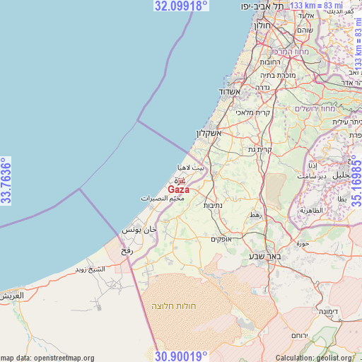
Gaza GPS coordinates[2]
31° 30' 5.796" North, 34° 28' 0.192" East
| Map corner | latitude | longitude |
|---|---|---|
| Upper-left | 32.09918°, | 33.7636° |
| Center: | 31.50161°, | 34.46672° |
| Lower-right: | 30.90019°, | 35.16985° |
| Map W x H: | 133.3×133.3 km | = 82.8×82.8mi |
| max Lat: | 32.54346° ⇑86.3% North |
| Gaza: | 31.50161° |
| min Lat: | ⇓13.7% South 31.25997° |
| min Long | Gaza | max Long |
| 34.24357° | 34.46672° | 35.53898° |
| W 4.6%⇐ | ⇒95.4% E |
Elevation
Elevation of Gaza is 38 m = 125 ft, and this is 435.3 m = 1428 ft below average elevation for this country.
| Max E: |
999 m = 3278 ft | 94.7% |
| Avg. | 473.3 m = 1553 ft | |
| Gaza | 38 m = 125 ft | |
Min E: |
-269 m = -883 ft | 5.3% |
See also: Gaza elevation on elevation.city.
Geographical zone
Gaza is located in North temperate zone (between Tropic of Cancer and the Arctic Circle). Distance of this Northern Tropic circle is 896.7 km =557.2 mi to South.| Distance of | km | miles | from Gaza |
|---|---|---|---|
| North Pole | 6504.4 | 4041.6 | to North |
| Arctic Circle | 3898.5 | 2422.4 | to North |
| Tropic Cancer | 896.7 | 557.2 | to South |
| Equator | 3502.7 | 2176.5 | to South |


Nearby cities:
15 places around Gaza: (largest is in red/bold)
• Al Burayj
9.2 km =5.7 mi,  221°
221°
• Al Mughrāqah
6.5 km =4 mi,  232°
232°
• Al Muşaddar
13.2 km =8.2 mi, 219°
• Al Qarārah
18.6 km =11.6 mi, 220°
• An Nuşayrāt
9.2 km =5.7 mi, 230°
• Az Zuwāydah
10.7 km =6.6 mi, 229°
• Banī Suhaylā
22.2 km =13.8 mi, 217°
• Bayt Lāhyā
5.7 km =3.5 mi,  28°
28°
• Bayt Ḩānūn
7.5 km =4.7 mi,  60°
60°
• Dayr al Balaḩ
14.4 km =8.9 mi, 229°
• Jabālyā
3.3 km =2.1 mi, 29°
• Juḩr ad Dīk
5.8 km =3.6 mi,  208°
208°
• Umm an Naşr
8.2 km =5.1 mi,  36°
36°
• Wādī as Salqā
16.6 km =10.3 mi, 227°
• ‘Abasān al Jadīdah
21.2 km =13.2 mi, 212°
Sources, notices
• [Note1] Compared only with cities in Palestinian Territory existing in our database
• [Src1] Map data: © OpenStreetMap contributors (CC-BY-SA)
• [Src2] Other city data from geonames.org with taken over terms of usage.
• [Src3] Geographical zone / Annual Mean Temperature by Robert A. Rohde @ Wikipedia
