Trigaches geodata
Trigaches (Beja) is a populated place; located in Portugal in Europe/Lisbon (GMT+0) time zone. With population of 572 people, there are 817 cities with bigger population in this country. Compared to other cities in Portugal, 83.1% of cities are located further ↑North; 80.2% of cities are located further ←West and 67% of cities have lower elevation than Trigaches. Note1


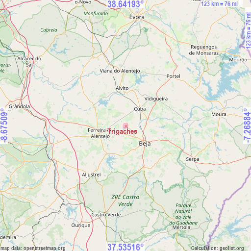
Trigaches GPS coordinates[2]
38° 5' 26.304" North, 7° 58' 19.056" West
| Map corner | latitude | longitude |
|---|---|---|
| Upper-left | 38.64193°, | -8.67509° |
| Center: | 38.09064°, | -7.97196° |
| Lower-right: | 37.53516°, | -7.26884° |
| Map W x H: | 123.1×123.1 km | = 76.5×76.5mi |
| max Lat: | 42.11337° ⇑83.1% North |
| Trigaches: | 38.09064° |
| min Lat: | ⇓16.9% South 32.6448° |
| min Long | Trigaches | max Long |
| -31.17847° | -7.97196° | -6.27308° |
| W 80.2%⇐ | ⇒19.8% E |
Elevation
Elevation of Trigaches is 186 m = 610 ft, and this is 9 m = 30 ft above average elevation for this country.
| Max E: |
1008 m = 3307 ft | 33% |
| Trigaches | 186 m 610 ft | |
| Avg. | 177 m = 581 ft | |
Min E: |
-128 m = -420 ft | 67% |
See also: Portugal elevation on elevation.city.
Geographical zone
Trigaches is located in North temperate zone (between Tropic of Cancer and the Arctic Circle). Distance of this Northern Tropic circle is 1629.4 km =1012.5 mi to South.| Distance of | km | miles | from Trigaches |
|---|---|---|---|
| North Pole | 5771.8 | 3586.4 | to North |
| Arctic Circle | 3165.9 | 1967.2 | to North |
| Tropic Cancer | 1629.4 | 1012.5 | to South |
| Equator | 4235.3 | 2631.7 | to South |


Nearby cities:
15 places around Trigaches: (largest is in red/bold)
• Alvito
18.5 km =11.5 mi,  354°
354°
• Beja
12.7 km =7.9 mi,  131°
131°
• Beringel
3.9 km =2.4 mi,  195°
195°
• Cuba
10.8 km =6.7 mi,  39°
39°
• Faro do Alentejo
7 km =4.3 mi,  22°
22°
• Ferreira do Alentejo
7 km =4.3 mi,  229°
229°
• Mombeja
9.4 km =5.8 mi,  217°
217°
• Neves
15.8 km =9.8 mi,  118°
118°
• Penedo Gordo
12.7 km =7.9 mi,  157°
157°
• Salvada
24.3 km =15.1 mi, 134°
• Santa Clara de Louredo
15.9 km =9.9 mi,  146°
146°
• Santa Vitória
14.4 km =8.9 mi, 199°
• São Brissos
3 km =1.9 mi, 132°
• São Matias
10.3 km =6.4 mi,  78°
78°
• Vidigueira
20 km =12.4 mi,  48°
48°
Sources, notices
• [Note1] Compared only with cities in Portugal existing in our database
• [Src1] Map data: © OpenStreetMap contributors (CC-BY-SA)
• [Src2] Other city data from geonames.org with taken over terms of usage.
• [Src3] Geographical zone / Annual Mean Temperature by Robert A. Rohde @ Wikipedia
