Salvada geodata
Salvada (Beja) is a populated place; located in Portugal in Europe/Lisbon (GMT+1) time zone. With population of 1,352 people, there are 705 cities with bigger population in this country. Compared to other cities in Portugal, 84.7% of cities are located further ↑North; 86.2% of cities are located further ←West and 66.1% of cities have lower elevation than Salvada. Note1


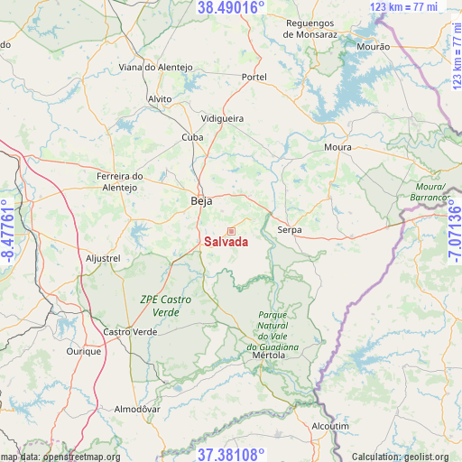
Salvada GPS coordinates[2]
37° 56' 15.756" North, 7° 46' 28.128" West
| Map corner | latitude | longitude |
|---|---|---|
| Upper-left | 38.49016°, | -8.47761° |
| Center: | 37.93771°, | -7.77448° |
| Lower-right: | 37.38108°, | -7.07136° |
| Map W x H: | 123.3×123.3 km | = 76.6×76.6mi |
| max Lat: | 42.11337° ⇑84.7% North |
| Salvada: | 37.93771° |
| min Lat: | ⇓15.3% South 32.6448° |
| min Long | Salvada | max Long |
| -31.17847° | -7.77448° | -6.27308° |
| W 86.2%⇐ | ⇒13.8% E |
Elevation
Elevation of Salvada is 183 m = 600 ft, and this is 6 m = 20 ft above average elevation for this country.
| Max E: |
1008 m = 3307 ft | 33.9% |
| Salvada | 183 m 600 ft | |
| Avg. | 177 m = 581 ft | |
Min E: |
-128 m = -420 ft | 66.1% |
See also: Portugal elevation on elevation.city.
Geographical zone
Salvada is located in North temperate zone (between Tropic of Cancer and the Arctic Circle). Distance of this Northern Tropic circle is 1612.4 km =1001.9 mi to South.| Distance of | km | miles | from Salvada |
|---|---|---|---|
| North Pole | 5788.8 | 3597 | to North |
| Arctic Circle | 3182.9 | 1977.8 | to North |
| Tropic Cancer | 1612.4 | 1001.9 | to South |
| Equator | 4218.3 | 2621.1 | to South |


Nearby cities:
15 places around Salvada: (largest is in red/bold)
• Beja
11.6 km =7.2 mi,  317°
317°
• Beringel
22.6 km =14 mi,  305°
305°
• Cabeça Gorda
2.2 km =1.4 mi,  226°
226°
• Cuba
27.3 km =17 mi,  337°
337°
• Faro do Alentejo
27.7 km =17.2 mi,  328°
328°
• Ferreira do Alentejo
25.9 km =16.1 mi,  298°
298°
• Mombeja
25 km =15.5 mi,  292°
292°
• Neves
10 km =6.2 mi, 340°
• Penedo Gordo
13.5 km =8.4 mi, 292°
• Santa Clara de Louredo
9.3 km =5.8 mi, 293°
• Santa Vitória
22.4 km =13.9 mi,  278°
278°
• Serpa
15.5 km =9.6 mi,  86°
86°
• São Brissos
21.2 km =13.2 mi, 314°
• São Matias
20.4 km =12.7 mi, 339°
• Trigaches
24.3 km =15.1 mi, 314°
Sources, notices
• [Note1] Compared only with cities in Portugal existing in our database
• [Src1] Map data: © OpenStreetMap contributors (CC-BY-SA)
• [Src2] Other city data from geonames.org with taken over terms of usage.
• [Src3] Geographical zone / Annual Mean Temperature by Robert A. Rohde @ Wikipedia
