Cuba geodata
Cuba (Beja) is a seat of a second-order administrative division; located in Portugal in Europe/Lisbon (GMT+1) time zone. With population of 4,878 people, there are 439 cities with bigger population in this country. Compared to other cities in Portugal, 82.6% of cities are located further ↑North; 82.7% of cities are located further ←West and 65.4% of cities have lower elevation than Cuba. Note1


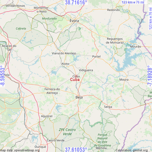
Cuba GPS coordinates[2]
38° 9' 55.584" North, 7° 53' 32.64" West
| Map corner | latitude | longitude |
|---|---|---|
| Upper-left | 38.71616°, | -8.59553° |
| Center: | 38.16544°, | -7.8924° |
| Lower-right: | 37.61053°, | -7.18928° |
| Map W x H: | 122.9×122.9 km | = 76.4×76.4mi |
| max Lat: | 42.11337° ⇑82.6% North |
| Cuba: | 38.16544° |
| min Lat: | ⇓17.4% South 32.6448° |
| min Long | Cuba | max Long |
| -31.17847° | -7.8924° | -6.27308° |
| W 82.7%⇐ | ⇒17.3% E |
Elevation
Elevation of Cuba is 180 m = 591 ft, and this is 3 m = 10 ft above average elevation for this country.
| Max E: |
1008 m = 3307 ft | 34.6% |
| Cuba | 180 m 591 ft | |
| Avg. | 177 m = 581 ft | |
Min E: |
-128 m = -420 ft | 65.4% |
See also: Portugal elevation on elevation.city.
Geographical zone
Cuba is located in North temperate zone (between Tropic of Cancer and the Arctic Circle). Distance of this Northern Tropic circle is 1637.7 km =1017.6 mi to South.| Distance of | km | miles | from Cuba |
|---|---|---|---|
| North Pole | 5763.5 | 3581.3 | to North |
| Arctic Circle | 3157.6 | 1962 | to North |
| Tropic Cancer | 1637.7 | 1017.6 | to South |
| Equator | 4243.6 | 2636.8 | to South |


Nearby cities:
15 places around Cuba: (largest is in red/bold)
• Alvito
13.3 km =8.3 mi,  319°
319°
• Beja
16.9 km =10.5 mi,  171°
171°
• Beringel
14.5 km =9 mi,  213°
213°
• Faro do Alentejo
4.7 km =2.9 mi,  246°
246°
• Ferreira do Alentejo
17.8 km =11.1 mi,  223°
223°
• Mombeja
20.2 km =12.6 mi, 218°
• Neves
17.3 km =10.7 mi,  156°
156°
• Penedo Gordo
20.2 km =12.6 mi,  185°
185°
• Portel
22.9 km =14.2 mi,  46°
46°
• Santa Clara de Louredo
21.7 km =13.5 mi,  175°
175°
• São Brissos
11.4 km =7.1 mi,  204°
204°
• São Matias
7 km =4.3 mi,  153°
153°
• Trigaches
10.8 km =6.7 mi, 219°
• Viana do Alentejo
21.2 km =13.2 mi,  332°
332°
• Vidigueira
9.4 km =5.8 mi,  58°
58°
Sources, notices
• [Note1] Compared only with cities in Portugal existing in our database
• [Src1] Map data: © OpenStreetMap contributors (CC-BY-SA)
• [Src2] Other city data from geonames.org with taken over terms of usage.
• [Src3] Geographical zone / Annual Mean Temperature by Robert A. Rohde @ Wikipedia
