Porto Salvo geodata
Porto Salvo (Lisbon) is a populated place; located in Portugal in Europe/Lisbon (GMT+1) time zone. With population of 13,867 people, there are 152 cities with bigger population in this country. Compared to other cities in Portugal, 72.6% of cities are located further ↑North; 86.2% of cities are located further →East and 51.9% of cities have higher elevation than Porto Salvo. Note1


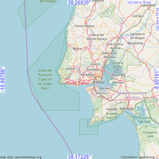
Porto Salvo GPS coordinates[2]
38° 43' 22.548" North, 9° 18' 17.028" West
| Map corner | latitude | longitude |
|---|---|---|
| Upper-left | 39.26939°, | -10.00786° |
| Center: | 38.72293°, | -9.30473° |
| Lower-right: | 38.17226°, | -8.60161° |
| Map W x H: | 122×122 km | = 75.8×75.8mi |
| max Lat: | 42.11337° ⇑72.6% North |
| Porto Salvo: | 38.72293° |
| min Lat: | ⇓27.4% South 32.6448° |
| min Long | Porto Salvo | max Long |
| -31.17847° | -9.30473° | -6.27308° |
| W 13.8%⇐ | ⇒86.2% E |
Elevation
Elevation of Porto Salvo is 105 m = 344 ft, and this is 72 m = 236 ft below average elevation for this country.
| Max E: |
1008 m = 3307 ft | 51.9% |
| Avg. | 177 m = 581 ft | |
| Porto Salvo | 105 m = 344 ft | |
Min E: |
-128 m = -420 ft | 48.1% |
See also: Portugal elevation on elevation.city.
Geographical zone
Porto Salvo is located in North temperate zone (between Tropic of Cancer and the Arctic Circle). Distance of this Northern Tropic circle is 1699.7 km =1056.1 mi to South.| Distance of | km | miles | from Porto Salvo |
|---|---|---|---|
| North Pole | 5701.5 | 3542.7 | to North |
| Arctic Circle | 3095.6 | 1923.5 | to North |
| Tropic Cancer | 1699.7 | 1056.1 | to South |
| Equator | 4305.6 | 2675.4 | to South |


Nearby cities:
15 places around Porto Salvo: (largest is in red/bold)
• Barcarena
2.4 km =1.5 mi,  63°
63°
• Cacém
4.9 km =3 mi,  6°
6°
• Carcavelos
3.9 km =2.4 mi,  203°
203°
• Carnaxide
5.1 km =3.2 mi,  84°
84°
• Caxias
3.3 km =2.1 mi,  132°
132°
• Linda-a-Velha
5.5 km =3.4 mi,  99°
99°
• Massamá
3.9 km =2.4 mi,  31°
31°
• Oeiras
3.6 km =2.2 mi,  188°
188°
• Parede
5.4 km =3.4 mi,  232°
232°
• Paço de Arcos
3.2 km =2 mi,  159°
159°
• Queijas
3.7 km =2.3 mi, 96°
• Queluz
5.7 km =3.5 mi,  49°
49°
• Rio de Mouro
5.2 km =3.2 mi,  337°
337°
• São Domingos de Rana
3.9 km =2.4 mi, 233°
• Terrugem
2.4 km =1.5 mi,  139°
139°
Sources, notices
• [Note1] Compared only with cities in Portugal existing in our database
• [Src1] Map data: © OpenStreetMap contributors (CC-BY-SA)
• [Src2] Other city data from geonames.org with taken over terms of usage.
• [Src3] Geographical zone / Annual Mean Temperature by Robert A. Rohde @ Wikipedia
