Cacém geodata
Cacém (Lisbon) is a populated place; located in Portugal in Europe/Lisbon (GMT+1) time zone. With population of 93,982 people, there are 8 cities with bigger population in this country. Compared to other cities in Portugal, 70.8% of cities are located further ↑North; 86.1% of cities are located further →East and 53.2% of cities have lower elevation than Cacém. Note1


Cacém GPS coordinates[2]
38° 46' 1.128" North, 9° 17' 52.548" West
| Map corner | latitude | longitude |
|---|---|---|
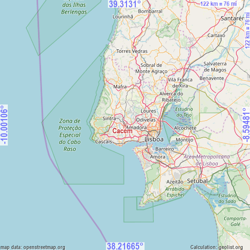
| Upper-left | 39.3131°, | -10.00106° |
| Center: | 38.76698°, | -9.29793° |
| Lower-right: | 38.21665°, | -8.59481° |
| Map W x H: | 121.9×121.9 km | = 75.7×75.7mi |
| max Lat: | 42.11337° ⇑70.8% North |
| Cacém: | 38.76698° |
| min Lat: | ⇓29.2% South 32.6448° |
| min Long | Cacém | max Long |
| -31.17847° | -9.29793° | -6.27308° |
| W 13.9%⇐ | ⇒86.1% E |
Elevation
Elevation of Cacém is 123 m = 404 ft, and this is 54 m = 177 ft below average elevation for this country.
| Max E: |
1008 m = 3307 ft | 46.8% |
| Avg. | 177 m = 581 ft | |
| Cacém | 123 m = 404 ft | |
Min E: |
-128 m = -420 ft | 53.2% |
See also: Cacém elevation on elevation.city.
Geographical zone
Cacém is located in North temperate zone (between Tropic of Cancer and the Arctic Circle). Distance of this Northern Tropic circle is 1704.6 km =1059.2 mi to South.| Distance of | km | miles | from Cacém |
|---|---|---|---|
| North Pole | 5696.6 | 3539.7 | to North |
| Arctic Circle | 3090.7 | 1920.5 | to North |
| Tropic Cancer | 1704.6 | 1059.2 | to South |
| Equator | 4310.5 | 2678.4 | to South |


Nearby cities:
15 places around Cacém: (largest is in red/bold)
• Algueirão
5.2 km =3.2 mi,  310°
310°
• Amadora
6 km =3.7 mi,  104°
104°
• Barcarena
4.1 km =2.5 mi,  157°
157°
• Belas
3.2 km =2 mi,  70°
70°
• Carnaxide
6.3 km =3.9 mi,  134°
134°
• Caxias
7.3 km =4.5 mi,  165°
165°
• Famões
7.9 km =4.9 mi, 72°
• Linda-a-Velha
7.6 km =4.7 mi,  140°
140°
• Massamá
2.1 km =1.3 mi, 137°
• Mem Martins
4.9 km =3 mi, 308°
• Porto Salvo
4.9 km =3 mi,  186°
186°
• Queijas
6.1 km =3.8 mi,  149°
149°
• Queluz
3.9 km =2.4 mi,  107°
107°
• Rio de Mouro
2.6 km =1.6 mi,  267°
267°
• Terrugem
6.8 km =4.2 mi, 171°
Sources, notices
• [Note1] Compared only with cities in Portugal existing in our database
• [Src1] Map data: © OpenStreetMap contributors (CC-BY-SA)
• [Src2] Other city data from geonames.org with taken over terms of usage.
• [Src3] Geographical zone / Annual Mean Temperature by Robert A. Rohde @ Wikipedia
