Oeiras geodata
Oeiras (Lisbon) is a seat of a second-order administrative division; located in Portugal in Europe/Lisbon (GMT+1) time zone. With population of 35,000 people, there are 36 cities with bigger population in this country. Compared to other cities in Portugal, 75.1% of cities are located further ↑North; 86.3% of cities are located further →East and 77.4% of cities have higher elevation than Oeiras. Note1


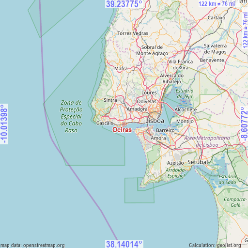
Oeiras GPS coordinates[2]
38° 41' 27.78" North, 9° 18' 39.06" West
| Map corner | latitude | longitude |
|---|---|---|
| Upper-left | 39.23775°, | -10.01398° |
| Center: | 38.69105°, | -9.31085° |
| Lower-right: | 38.14014°, | -8.60772° |
| Map W x H: | 122×122 km | = 75.8×75.8mi |
| max Lat: | 42.11337° ⇑75.1% North |
| Oeiras: | 38.69105° |
| min Lat: | ⇓24.9% South 32.6448° |
| min Long | Oeiras | max Long |
| -31.17847° | -9.31085° | -6.27308° |
| W 13.7%⇐ | ⇒86.3% E |
Elevation
Elevation of Oeiras is 36 m = 118 ft, and this is 141 m = 463 ft below average elevation for this country.
| Max E: |
1008 m = 3307 ft | 77.4% |
| Avg. | 177 m = 581 ft | |
| Oeiras | 36 m = 118 ft | |
Min E: |
-128 m = -420 ft | 22.6% |
See also: Portugal elevation on elevation.city.
Geographical zone
Oeiras is located in North temperate zone (between Tropic of Cancer and the Arctic Circle). Distance of this Northern Tropic circle is 1696.1 km =1053.9 mi to South.| Distance of | km | miles | from Oeiras |
|---|---|---|---|
| North Pole | 5705 | 3544.9 | to North |
| Arctic Circle | 3099.1 | 1925.7 | to North |
| Tropic Cancer | 1696.1 | 1053.9 | to South |
| Equator | 4302 | 2673.1 | to South |


Nearby cities:
15 places around Oeiras: (largest is in red/bold)
• Algés
7.2 km =4.5 mi,  79°
79°
• Barcarena
5.3 km =3.3 mi,  30°
30°
• Carcavelos
1 km =0.6 mi,  270°
270°
• Carnaxide
6.9 km =4.3 mi,  54°
54°
• Caxias
3.3 km =2.1 mi,  65°
65°
• Estoril
7.7 km =4.8 mi,  282°
282°
• Linda-a-Velha
6.5 km =4 mi, 66°
• Massamá
7.3 km =4.5 mi,  20°
20°
• Parede
3.8 km =2.4 mi, 273°
• Paço de Arcos
1.8 km =1.1 mi, 72°
• Porto Salvo
3.6 km =2.2 mi,  8°
8°
• Queijas
5.2 km =3.2 mi, 53°
• São Domingos de Rana
2.9 km =1.8 mi,  294°
294°
• Terrugem
2.7 km =1.7 mi, 50°
• Trafaria
7.1 km =4.4 mi,  107°
107°
Sources, notices
• [Note1] Compared only with cities in Portugal existing in our database
• [Src1] Map data: © OpenStreetMap contributors (CC-BY-SA)
• [Src2] Other city data from geonames.org with taken over terms of usage.
• [Src3] Geographical zone / Annual Mean Temperature by Robert A. Rohde @ Wikipedia
