Montijo geodata
Montijo (District of Setúbal) is a seat of a second-order administrative division; located in Portugal in Europe/Lisbon (GMT+1) time zone. With population of 30,011 people, there are 49 cities with bigger population in this country. Compared to other cities in Portugal, 73.5% of cities are located further ↑North; 72.9% of cities are located further →East and 96.2% of cities have higher elevation than Montijo. Note1


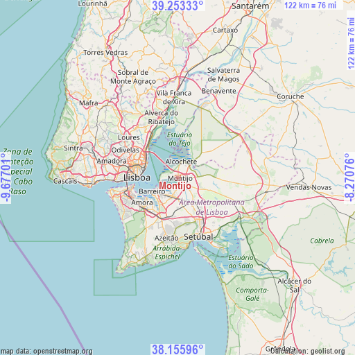
Montijo GPS coordinates[2]
38° 42' 24.3" North, 8° 58' 25.968" West
| Map corner | latitude | longitude |
|---|---|---|
| Upper-left | 39.25333°, | -9.67701° |
| Center: | 38.70675°, | -8.97388° |
| Lower-right: | 38.15596°, | -8.27076° |
| Map W x H: | 122×122 km | = 75.8×75.8mi |
| max Lat: | 42.11337° ⇑73.5% North |
| Montijo: | 38.70675° |
| min Lat: | ⇓26.5% South 32.6448° |
| min Long | Montijo | max Long |
| -31.17847° | -8.97388° | -6.27308° |
| W 27.1%⇐ | ⇒72.9% E |
Elevation
Elevation of Montijo is 9 m = 30 ft, and this is 168 m = 551 ft below average elevation for this country.
| Max E: |
1008 m = 3307 ft | 96.2% |
| Avg. | 177 m = 581 ft | |
| Montijo | 9 m = 30 ft | |
Min E: |
-128 m = -420 ft | 3.8% |
See also: Portugal elevation on elevation.city.
Geographical zone
Montijo is located in North temperate zone (between Tropic of Cancer and the Arctic Circle). Distance of this Northern Tropic circle is 1697.9 km =1055 mi to South.| Distance of | km | miles | from Montijo |
|---|---|---|---|
| North Pole | 5703.3 | 3543.9 | to North |
| Arctic Circle | 3097.4 | 1924.6 | to North |
| Tropic Cancer | 1697.9 | 1055 | to South |
| Equator | 4303.8 | 2674.3 | to South |


Nearby cities:
15 places around Montijo: (largest is in red/bold)
• Alcochete
5.5 km =3.4 mi,  11°
11°
• Aldeia de Paio Pires
13.8 km =8.6 mi,  223°
223°
• Alhos Vedros
7.2 km =4.5 mi, 216°
• Barreiro
9.8 km =6.1 mi,  240°
240°
• Beato António
11.6 km =7.2 mi,  284°
284°
• Lavradio
8 km =5 mi, 237°
• Moita
6.4 km =4 mi,  192°
192°
• Moscavide e Portela
13.7 km =8.5 mi,  305°
305°
• Olivais
13.5 km =8.4 mi,  301°
301°
• Pinhal Novo
9.9 km =6.2 mi,  148°
148°
• Rosairinho
4.4 km =2.7 mi, 222°
• Samouco
3.1 km =1.9 mi, 299°
• Santo António da Charneca
10.3 km =6.4 mi,  208°
208°
• Sarilhos Pequenos
2.9 km =1.8 mi, 194°
• Seixal
13.3 km =8.3 mi, 236°
Sources, notices
• [Note1] Compared only with cities in Portugal existing in our database
• [Src1] Map data: © OpenStreetMap contributors (CC-BY-SA)
• [Src2] Other city data from geonames.org with taken over terms of usage.
• [Src3] Geographical zone / Annual Mean Temperature by Robert A. Rohde @ Wikipedia
