Alcochete geodata
Alcochete (District of Setúbal) is a seat of a second-order administrative division; located in Portugal in Europe/Lisbon (GMT+1) time zone. With population of 9,705 people, there are 223 cities with bigger population in this country. Compared to other cities in Portugal, 71.3% of cities are located further ↑North; 72.5% of cities are located further →East and 94.1% of cities have higher elevation than Alcochete. Note1


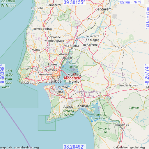
Alcochete GPS coordinates[2]
38° 45' 19.224" North, 8° 57' 39.096" West
| Map corner | latitude | longitude |
|---|---|---|
| Upper-left | 39.30155°, | -9.66399° |
| Center: | 38.75534°, | -8.96086° |
| Lower-right: | 38.20492°, | -8.25774° |
| Map W x H: | 121.9×121.9 km | = 75.7×75.7mi |
| max Lat: | 42.11337° ⇑71.3% North |
| Alcochete: | 38.75534° |
| min Lat: | ⇓28.7% South 32.6448° |
| min Long | Alcochete | max Long |
| -31.17847° | -8.96086° | -6.27308° |
| W 27.5%⇐ | ⇒72.5% E |
Elevation
Elevation of Alcochete is 11 m = 36 ft, and this is 166 m = 545 ft below average elevation for this country.
| Max E: |
1008 m = 3307 ft | 94.1% |
| Avg. | 177 m = 581 ft | |
| Alcochete | 11 m = 36 ft | |
Min E: |
-128 m = -420 ft | 5.9% |
See also: Portugal elevation on elevation.city.
Geographical zone
Alcochete is located in North temperate zone (between Tropic of Cancer and the Arctic Circle). Distance of this Northern Tropic circle is 1703.3 km =1058.4 mi to South.| Distance of | km | miles | from Alcochete |
|---|---|---|---|
| North Pole | 5697.9 | 3540.5 | to North |
| Arctic Circle | 3092 | 1921.3 | to North |
| Tropic Cancer | 1703.3 | 1058.4 | to South |
| Equator | 4309.2 | 2677.6 | to South |


Nearby cities:
15 places around Alcochete: (largest is in red/bold)
• Alhos Vedros
12.4 km =7.7 mi,  206°
206°
• Barreiro
14.1 km =8.8 mi,  223°
223°
• Beato António
12.6 km =7.8 mi,  258°
258°
• Bobadela
13.3 km =8.3 mi,  295°
295°
• Lavradio
12.5 km =7.8 mi, 219°
• Moita
11.9 km =7.4 mi,  192°
192°
• Montijo
5.5 km =3.4 mi, 191°
• Moscavide e Portela
12.5 km =7.8 mi,  282°
282°
• Olivais
12.8 km =8 mi, 277°
• Pinhal Novo
14.4 km =8.9 mi,  163°
163°
• Rosairinho
9.6 km =6 mi, 205°
• Sacavém
13.4 km =8.3 mi,  287°
287°
• Samouco
5.4 km =3.4 mi, 224°
• Sarilhos Pequenos
8.4 km =5.2 mi, 192°
• São João da Talha
14.1 km =8.8 mi, 302°
Sources, notices
• [Note1] Compared only with cities in Portugal existing in our database
• [Src1] Map data: © OpenStreetMap contributors (CC-BY-SA)
• [Src2] Other city data from geonames.org with taken over terms of usage.
• [Src3] Geographical zone / Annual Mean Temperature by Robert A. Rohde @ Wikipedia
