Ferrel geodata
Ferrel (Leiria) is a populated place; located in Portugal in Europe/Lisbon (GMT+1) time zone. With population of 2,649 people, there are 602 cities with bigger population in this country. Compared to other cities in Portugal, 57% of cities are located further ↑North; 86.5% of cities are located further →East and 82.4% of cities have higher elevation than Ferrel. Note1


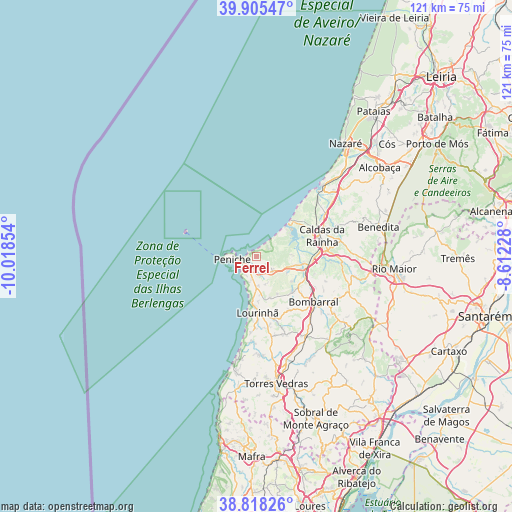
Ferrel GPS coordinates[2]
39° 21' 50.328" North, 9° 18' 55.476" West
| Map corner | latitude | longitude |
|---|---|---|
| Upper-left | 39.90547°, | -10.01854° |
| Center: | 39.36398°, | -9.31541° |
| Lower-right: | 38.81826°, | -8.61228° |
| Map W x H: | 120.9×120.9 km | = 75.1×75.1mi |
| max Lat: | 42.11337° ⇑57% North |
| Ferrel: | 39.36398° |
| min Lat: | ⇓43% South 32.6448° |
| min Long | Ferrel | max Long |
| -31.17847° | -9.31541° | -6.27308° |
| W 13.5%⇐ | ⇒86.5% E |
Elevation
Elevation of Ferrel is 28 m = 92 ft, and this is 149 m = 489 ft below average elevation for this country.
| Max E: |
1008 m = 3307 ft | 82.4% |
| Avg. | 177 m = 581 ft | |
| Ferrel | 28 m = 92 ft | |
Min E: |
-128 m = -420 ft | 17.6% |
See also: Portugal elevation on elevation.city.
Geographical zone
Ferrel is located in North temperate zone (between Tropic of Cancer and the Arctic Circle). Distance of this Northern Tropic circle is 1770.9 km =1100.4 mi to South.| Distance of | km | miles | from Ferrel |
|---|---|---|---|
| North Pole | 5630.2 | 3498.4 | to North |
| Arctic Circle | 3024.3 | 1879.2 | to North |
| Tropic Cancer | 1770.9 | 1100.4 | to South |
| Equator | 4376.9 | 2719.7 | to South |


Nearby cities:
15 places around Ferrel: (largest is in red/bold)
• Atouguia da Baleia
3 km =1.9 mi,  198°
198°
• Bombarral
17.3 km =10.7 mi,  128°
128°
• Caldas da Rainha
15.8 km =9.8 mi,  73°
73°
• Campelos
19.8 km =12.3 mi,  159°
159°
• Foz do Arelho
11.9 km =7.4 mi,  47°
47°
• Lourinhã
13.6 km =8.5 mi,  178°
178°
• Moita dos Ferreiros
15.1 km =9.4 mi,  148°
148°
• Nadadouro
12.3 km =7.6 mi,  60°
60°
• Peniche
5.7 km =3.5 mi,  260°
260°
• Salir de Matos
20.4 km =12.7 mi, 68°
• Salir do Porto
20 km =12.4 mi,  43°
43°
• Serra de El-Rei
5.3 km =3.3 mi, 130°
• Serra do Bouro
15.5 km =9.6 mi, 49°
• São Bartolomeu
10.4 km =6.5 mi, 162°
• Óbidos
13.6 km =8.5 mi,  91°
91°
Sources, notices
• [Note1] Compared only with cities in Portugal existing in our database
• [Src1] Map data: © OpenStreetMap contributors (CC-BY-SA)
• [Src2] Other city data from geonames.org with taken over terms of usage.
• [Src3] Geographical zone / Annual Mean Temperature by Robert A. Rohde @ Wikipedia
