Bombarral geodata
Bombarral (Leiria) is a seat of a second-order administrative division; located in Portugal in Europe/Lisbon (GMT+1) time zone. With population of 5,852 people, there are 370 cities with bigger population in this country. Compared to other cities in Portugal, 58.9% of cities are located further ↑North; 81.2% of cities are located further →East and 71.6% of cities have higher elevation than Bombarral. Note1


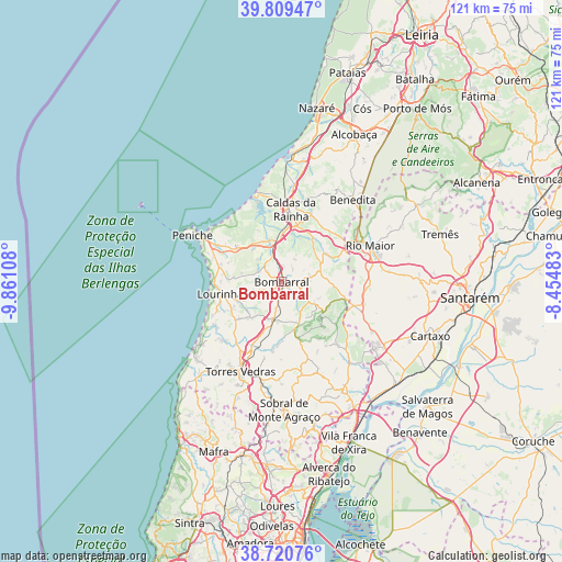
Bombarral GPS coordinates[2]
39° 16' 2.028" North, 9° 9' 28.62" West
| Map corner | latitude | longitude |
|---|---|---|
| Upper-left | 39.80947°, | -9.86108° |
| Center: | 39.26723°, | -9.15795° |
| Lower-right: | 38.72076°, | -8.45483° |
| Map W x H: | 121.1×121.1 km | = 75.2×75.2mi |
| max Lat: | 42.11337° ⇑58.9% North |
| Bombarral: | 39.26723° |
| min Lat: | ⇓41.1% South 32.6448° |
| min Long | Bombarral | max Long |
| -31.17847° | -9.15795° | -6.27308° |
| W 18.8%⇐ | ⇒81.2% E |
Elevation
Elevation of Bombarral is 47 m = 154 ft, and this is 130 m = 427 ft below average elevation for this country.
| Max E: |
1008 m = 3307 ft | 71.6% |
| Avg. | 177 m = 581 ft | |
| Bombarral | 47 m = 154 ft | |
Min E: |
-128 m = -420 ft | 28.4% |
See also: Portugal elevation on elevation.city.
Geographical zone
Bombarral is located in North temperate zone (between Tropic of Cancer and the Arctic Circle). Distance of this Northern Tropic circle is 1760.2 km =1093.7 mi to South.| Distance of | km | miles | from Bombarral |
|---|---|---|---|
| North Pole | 5641 | 3505.2 | to North |
| Arctic Circle | 3035.1 | 1885.9 | to North |
| Tropic Cancer | 1760.2 | 1093.7 | to South |
| Equator | 4366.1 | 2713 | to South |


Nearby cities:
15 places around Bombarral: (largest is in red/bold)
• A dos Francos
11.3 km =7 mi,  57°
57°
• Alvorninha
16.5 km =10.3 mi,  39°
39°
• Atouguia da Baleia
16.5 km =10.3 mi,  298°
298°
• Cabanas de Torres
14.7 km =9.1 mi,  147°
147°
• Cadaval
5.4 km =3.4 mi,  119°
119°
• Caldas da Rainha
15.2 km =9.4 mi,  6°
6°
• Campelos
10.3 km =6.4 mi,  220°
220°
• Lourinhã
13.6 km =8.5 mi,  257°
257°
• Moita dos Ferreiros
6 km =3.7 mi,  249°
249°
• Serra de El-Rei
12 km =7.5 mi,  307°
307°
• São Bartolomeu
10.4 km =6.5 mi,  274°
274°
• Ventosa
16.8 km =10.4 mi,  157°
157°
• Vidais
14.7 km =9.1 mi, 39°
• Vila Verde
13 km =8.1 mi, 163°
• Óbidos
10.4 km =6.5 mi,  0°
0°
Sources, notices
• [Note1] Compared only with cities in Portugal existing in our database
• [Src1] Map data: © OpenStreetMap contributors (CC-BY-SA)
• [Src2] Other city data from geonames.org with taken over terms of usage.
• [Src3] Geographical zone / Annual Mean Temperature by Robert A. Rohde @ Wikipedia
