Campelos geodata
Campelos (Lisbon) is a populated place; located in Portugal in Europe/Lisbon (GMT+1) time zone. With population of 3,667 people, there are 551 cities with bigger population in this country. Compared to other cities in Portugal, 60.3% of cities are located further ↑North; 84% of cities are located further →East and 51.1% of cities have higher elevation than Campelos. Note1


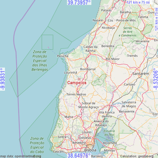
Campelos GPS coordinates[2]
39° 11' 48.408" North, 9° 14' 6.684" West
| Map corner | latitude | longitude |
|---|---|---|
| Upper-left | 39.73957°, | -9.93831° |
| Center: | 39.19678°, | -9.23519° |
| Lower-right: | 38.64976°, | -8.53206° |
| Map W x H: | 121.2×121.2 km | = 75.3×75.3mi |
| max Lat: | 42.11337° ⇑60.3% North |
| Campelos: | 39.19678° |
| min Lat: | ⇓39.7% South 32.6448° |
| min Long | Campelos | max Long |
| -31.17847° | -9.23519° | -6.27308° |
| W 16%⇐ | ⇒84% E |
Elevation
Elevation of Campelos is 109 m = 358 ft, and this is 68 m = 223 ft below average elevation for this country.
| Max E: |
1008 m = 3307 ft | 51.1% |
| Avg. | 177 m = 581 ft | |
| Campelos | 109 m = 358 ft | |
Min E: |
-128 m = -420 ft | 48.9% |
See also: Portugal elevation on elevation.city.
Geographical zone
Campelos is located in North temperate zone (between Tropic of Cancer and the Arctic Circle). Distance of this Northern Tropic circle is 1752.4 km =1088.9 mi to South.| Distance of | km | miles | from Campelos |
|---|---|---|---|
| North Pole | 5648.8 | 3510 | to North |
| Arctic Circle | 3042.9 | 1890.8 | to North |
| Tropic Cancer | 1752.4 | 1088.9 | to South |
| Equator | 4358.3 | 2708.1 | to South |


Nearby cities:
15 places around Campelos: (largest is in red/bold)
• A dos Cunhados
7.3 km =4.5 mi,  227°
227°
• Atouguia da Baleia
17.6 km =10.9 mi,  333°
333°
• Bombarral
10.3 km =6.4 mi,  40°
40°
• Cabanas de Torres
15.3 km =9.5 mi,  107°
107°
• Cadaval
12.5 km =7.8 mi,  65°
65°
• Lourinhã
8.3 km =5.2 mi,  306°
306°
• Moita dos Ferreiros
5.8 km =3.6 mi,  9°
9°
• Serra de El-Rei
15.4 km =9.6 mi,  349°
349°
• Silveira
14.6 km =9.1 mi, 229°
• São Bartolomeu
9.5 km =5.9 mi,  336°
336°
• São Pedro da Cadeira
18.4 km =11.4 mi,  219°
219°
• Torres Vedras
11.9 km =7.4 mi,  189°
189°
• Ventosa
15.2 km =9.4 mi,  120°
120°
• Vila Verde
11.3 km =7 mi, 114°
• Vimeiro
7.4 km =4.6 mi,  253°
253°
Sources, notices
• [Note1] Compared only with cities in Portugal existing in our database
• [Src1] Map data: © OpenStreetMap contributors (CC-BY-SA)
• [Src2] Other city data from geonames.org with taken over terms of usage.
• [Src3] Geographical zone / Annual Mean Temperature by Robert A. Rohde @ Wikipedia
