Carregado geodata
Carregado (Lisbon) is a populated place; located in Portugal in Europe/Lisbon (GMT+1) time zone. With population of 10,474 people, there are 212 cities with bigger population in this country. Compared to other cities in Portugal, 64% of cities are located further ↑North; 73% of cities are located further →East and 86.8% of cities have higher elevation than Carregado. Note1


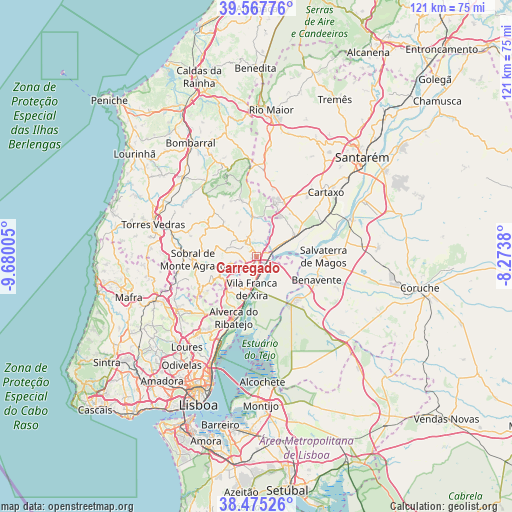
Carregado GPS coordinates[2]
39° 1' 25.032" North, 8° 58' 36.912" West
| Map corner | latitude | longitude |
|---|---|---|
| Upper-left | 39.56776°, | -9.68005° |
| Center: | 39.02362°, | -8.97692° |
| Lower-right: | 38.47526°, | -8.2738° |
| Map W x H: | 121.5×121.5 km | = 75.5×75.5mi |
| max Lat: | 42.11337° ⇑64% North |
| Carregado: | 39.02362° |
| min Lat: | ⇓36% South 32.6448° |
| min Long | Carregado | max Long |
| -31.17847° | -8.97692° | -6.27308° |
| W 27%⇐ | ⇒73% E |
Elevation
Elevation of Carregado is 21 m = 69 ft, and this is 156 m = 512 ft below average elevation for this country.
| Max E: |
1008 m = 3307 ft | 86.8% |
| Avg. | 177 m = 581 ft | |
| Carregado | 21 m = 69 ft | |
Min E: |
-128 m = -420 ft | 13.2% |
See also: Portugal elevation on elevation.city.
Geographical zone
Carregado is located in North temperate zone (between Tropic of Cancer and the Arctic Circle). Distance of this Northern Tropic circle is 1733.1 km =1076.9 mi to South.| Distance of | km | miles | from Carregado |
|---|---|---|---|
| North Pole | 5668 | 3521.9 | to North |
| Arctic Circle | 3062.2 | 1902.8 | to North |
| Tropic Cancer | 1733.1 | 1076.9 | to South |
| Equator | 4339 | 2696.1 | to South |


Nearby cities:
15 places around Carregado: (largest is in red/bold)
• Abrigada
13.9 km =8.6 mi,  344°
344°
• Alenquer
4.3 km =2.7 mi,  319°
319°
• Alhandra
11.1 km =6.9 mi,  194°
194°
• Arruda dos Vinhos
9.7 km =6 mi,  243°
243°
• Aveiras de Cima
14.4 km =8.9 mi,  27°
27°
• Azambuja
10.7 km =6.6 mi,  61°
61°
• Cadafais
3.2 km =2 mi,  228°
228°
• Castanheira do Ribatejo
3.4 km =2.1 mi,  174°
174°
• Meca
8.2 km =5.1 mi, 322°
• Ota
9.9 km =6.2 mi,  352°
352°
• Pereiro da Palhacana
11.8 km =7.3 mi,  280°
280°
• Samora Correia
13.2 km =8.2 mi,  136°
136°
• Sobralinho
12.6 km =7.8 mi,  199°
199°
• São João dos Montes
10 km =6.2 mi, 201°
• Vila Franca de Xira
7.7 km =4.8 mi, 188°
Sources, notices
• [Note1] Compared only with cities in Portugal existing in our database
• [Src1] Map data: © OpenStreetMap contributors (CC-BY-SA)
• [Src2] Other city data from geonames.org with taken over terms of usage.
• [Src3] Geographical zone / Annual Mean Temperature by Robert A. Rohde @ Wikipedia
