Sobralinho geodata
Sobralinho (Lisbon) is a populated place; located in Portugal in Europe/Lisbon (GMT+1) time zone. With population of 4,453 people, there are 475 cities with bigger population in this country. Compared to other cities in Portugal, 66.3% of cities are located further ↑North; 75.1% of cities are located further →East and 72.1% of cities have higher elevation than Sobralinho. Note1


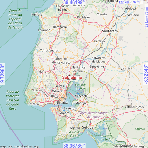
Sobralinho GPS coordinates[2]
38° 55' 1.308" North, 9° 1' 35.616" West
| Map corner | latitude | longitude |
|---|---|---|
| Upper-left | 39.46199°, | -9.72968° |
| Center: | 38.91703°, | -9.02656° |
| Lower-right: | 38.36785°, | -8.32343° |
| Map W x H: | 121.7×121.7 km | = 75.6×75.6mi |
| max Lat: | 42.11337° ⇑66.3% North |
| Sobralinho: | 38.91703° |
| min Lat: | ⇓33.7% South 32.6448° |
| min Long | Sobralinho | max Long |
| -31.17847° | -9.02656° | -6.27308° |
| W 24.9%⇐ | ⇒75.1% E |
Elevation
Elevation of Sobralinho is 46 m = 151 ft, and this is 131 m = 430 ft below average elevation for this country.
| Max E: |
1008 m = 3307 ft | 72.1% |
| Avg. | 177 m = 581 ft | |
| Sobralinho | 46 m = 151 ft | |
Min E: |
-128 m = -420 ft | 27.9% |
See also: Portugal elevation on elevation.city.
Geographical zone
Sobralinho is located in North temperate zone (between Tropic of Cancer and the Arctic Circle). Distance of this Northern Tropic circle is 1721.2 km =1069.5 mi to South.| Distance of | km | miles | from Sobralinho |
|---|---|---|---|
| North Pole | 5679.9 | 3529.3 | to North |
| Arctic Circle | 3074 | 1910.1 | to North |
| Tropic Cancer | 1721.2 | 1069.5 | to South |
| Equator | 4327.2 | 2688.8 | to South |


Nearby cities:
15 places around Sobralinho: (largest is in red/bold)
• Alhandra
1.9 km =1.2 mi,  53°
53°
• Arranhó
10.2 km =6.3 mi,  293°
293°
• Arruda dos Vinhos
8.7 km =5.4 mi,  329°
329°
• Bucelas
8.2 km =5.1 mi,  258°
258°
• Cadafais
9.9 km =6.2 mi,  11°
11°
• Carregado
12.6 km =7.8 mi,  19°
19°
• Castanheira do Ribatejo
9.6 km =6 mi,  28°
28°
• Póvoa de Santa Iria
7 km =4.3 mi,  207°
207°
• Santa Iria da Azóia
10.5 km =6.5 mi,  216°
216°
• Santo Antão do Tojal
12.2 km =7.6 mi,  233°
233°
• São João da Talha
12 km =7.5 mi, 210°
• São João dos Montes
2.6 km =1.6 mi, 14°
• Unhos
13.5 km =8.4 mi, 216°
• Vialonga
6.7 km =4.2 mi, 221°
• Vila Franca de Xira
5.3 km =3.3 mi,  36°
36°
Sources, notices
• [Note1] Compared only with cities in Portugal existing in our database
• [Src1] Map data: © OpenStreetMap contributors (CC-BY-SA)
• [Src2] Other city data from geonames.org with taken over terms of usage.
• [Src3] Geographical zone / Annual Mean Temperature by Robert A. Rohde @ Wikipedia
