Azambuja geodata
Azambuja (Lisbon) is a seat of a second-order administrative division; located in Portugal in Europe/Lisbon (GMT+1) time zone. With population of 7,179 people, there are 316 cities with bigger population in this country. Compared to other cities in Portugal, 62.7% of cities are located further ↑North; 70.6% of cities are located further →East and 84% of cities have higher elevation than Azambuja. Note1


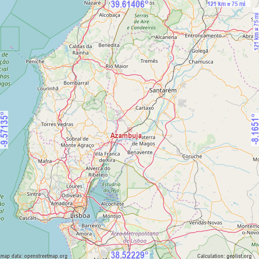
Azambuja GPS coordinates[2]
39° 4' 13.044" North, 8° 52' 5.592" West
| Map corner | latitude | longitude |
|---|---|---|
| Upper-left | 39.61406°, | -9.57135° |
| Center: | 39.07029°, | -8.86822° |
| Lower-right: | 38.52229°, | -8.1651° |
| Map W x H: | 121.4×121.4 km | = 75.4×75.4mi |
| max Lat: | 42.11337° ⇑62.7% North |
| Azambuja: | 39.07029° |
| min Lat: | ⇓37.3% South 32.6448° |
| min Long | Azambuja | max Long |
| -31.17847° | -8.86822° | -6.27308° |
| W 29.4%⇐ | ⇒70.6% E |
Elevation
Elevation of Azambuja is 25 m = 82 ft, and this is 152 m = 499 ft below average elevation for this country.
| Max E: |
1008 m = 3307 ft | 84% |
| Avg. | 177 m = 581 ft | |
| Azambuja | 25 m = 82 ft | |
Min E: |
-128 m = -420 ft | 16% |
See also: Portugal elevation on elevation.city.
Geographical zone
Azambuja is located in North temperate zone (between Tropic of Cancer and the Arctic Circle). Distance of this Northern Tropic circle is 1738.3 km =1080.1 mi to South.| Distance of | km | miles | from Azambuja |
|---|---|---|---|
| North Pole | 5662.9 | 3518.8 | to North |
| Arctic Circle | 3057 | 1899.5 | to North |
| Tropic Cancer | 1738.3 | 1080.1 | to South |
| Equator | 4344.2 | 2699.4 | to South |


Nearby cities:
15 places around Azambuja: (largest is in red/bold)
• Abrigada
15.4 km =9.6 mi,  302°
302°
• Alenquer
12.3 km =7.6 mi,  261°
261°
• Aveiras de Cima
8 km =5 mi,  340°
340°
• Benavente
11.4 km =7.1 mi,  152°
152°
• Cadafais
13.8 km =8.6 mi,  238°
238°
• Carregado
10.7 km =6.6 mi, 241°
• Cartaxo
12.2 km =7.6 mi,  34°
34°
• Castanheira do Ribatejo
12.5 km =7.8 mi,  226°
226°
• Marinhais
14.5 km =9 mi,  100°
100°
• Meca
14.4 km =8.9 mi,  275°
275°
• Ota
11.6 km =7.2 mi,  293°
293°
• Pontével
9.2 km =5.7 mi,  16°
16°
• Salvaterra de Magos
8 km =5 mi,  126°
126°
• Samora Correia
14.8 km =9.2 mi,  181°
181°
• Vila Chã de Ourique
14.3 km =8.9 mi,  37°
37°
Sources, notices
• [Note1] Compared only with cities in Portugal existing in our database
• [Src1] Map data: © OpenStreetMap contributors (CC-BY-SA)
• [Src2] Other city data from geonames.org with taken over terms of usage.
• [Src3] Geographical zone / Annual Mean Temperature by Robert A. Rohde @ Wikipedia
