Arrentela geodata
Arrentela (District of Setúbal) is a populated place; located in Portugal in Europe/Lisbon (GMT+1) time zone. With population of 30,156 people, there are 48 cities with bigger population in this country. Compared to other cities in Portugal, 79.1% of cities are located further ↑North; 77.8% of cities are located further →East and 79.8% of cities have higher elevation than Arrentela. Note1


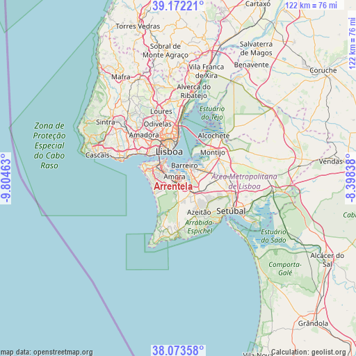
Arrentela GPS coordinates[2]
38° 37' 30" North, 9° 6' 5.436" West
| Map corner | latitude | longitude |
|---|---|---|
| Upper-left | 39.17221°, | -9.80463° |
| Center: | 38.625°, | -9.10151° |
| Lower-right: | 38.07358°, | -8.39838° |
| Map W x H: | 122.2×122.2 km | = 75.9×75.9mi |
| max Lat: | 42.11337° ⇑79.1% North |
| Arrentela: | 38.625° |
| min Lat: | ⇓20.9% South 32.6448° |
| min Long | Arrentela | max Long |
| -31.17847° | -9.10151° | -6.27308° |
| W 22.2%⇐ | ⇒77.8% E |
Elevation
Elevation of Arrentela is 33 m = 108 ft, and this is 144 m = 472 ft below average elevation for this country.
| Max E: |
1008 m = 3307 ft | 79.8% |
| Avg. | 177 m = 581 ft | |
| Arrentela | 33 m = 108 ft | |
Min E: |
-128 m = -420 ft | 20.2% |
See also: Portugal elevation on elevation.city.
Geographical zone
Arrentela is located in North temperate zone (between Tropic of Cancer and the Arctic Circle). Distance of this Northern Tropic circle is 1688.8 km =1049.4 mi to South.| Distance of | km | miles | from Arrentela |
|---|---|---|---|
| North Pole | 5712.4 | 3549.5 | to North |
| Arctic Circle | 3106.5 | 1930.3 | to North |
| Tropic Cancer | 1688.8 | 1049.4 | to South |
| Equator | 4294.7 | 2668.6 | to South |


Nearby cities:
15 places around Arrentela: (largest is in red/bold)
• Aldeia de Paio Pires
1.8 km =1.1 mi,  120°
120°
• Alhos Vedros
7.5 km =4.7 mi,  63°
63°
• Almada
7.7 km =4.8 mi,  321°
321°
• Amora
1.3 km =0.8 mi,  292°
292°
• Barreiro
4.9 km =3 mi,  30°
30°
• Cacilhas
8 km =5 mi,  328°
328°
• Charneca de Caparica
8.1 km =5 mi,  266°
266°
• Corroios
4.6 km =2.9 mi, 291°
• Laranjeira
5.7 km =3.5 mi,  307°
307°
• Lavradio
6.4 km =4 mi,  41°
41°
• Piedade
7 km =4.3 mi, 315°
• Pragal
8.1 km =5 mi, 312°
• Santo António da Charneca
6.2 km =3.9 mi,  89°
89°
• Seixal
1.7 km =1.1 mi,  0°
0°
• Sobreda
8.1 km =5 mi, 289°
Sources, notices
• [Note1] Compared only with cities in Portugal existing in our database
• [Src1] Map data: © OpenStreetMap contributors (CC-BY-SA)
• [Src2] Other city data from geonames.org with taken over terms of usage.
• [Src3] Geographical zone / Annual Mean Temperature by Robert A. Rohde @ Wikipedia
