Corroios geodata
Corroios (District of Setúbal) is a populated place; located in Portugal in Europe/Lisbon (GMT+1) time zone. With population of 52,520 people, there are 18 cities with bigger population in this country. Compared to other cities in Portugal, 78.5% of cities are located further ↑North; 80.4% of cities are located further →East and 88.3% of cities have higher elevation than Corroios. Note1


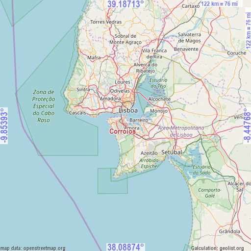
Corroios GPS coordinates[2]
38° 38' 24.144" North, 9° 9' 2.88" West
| Map corner | latitude | longitude |
|---|---|---|
| Upper-left | 39.18713°, | -9.85393° |
| Center: | 38.64004°, | -9.1508° |
| Lower-right: | 38.08874°, | -8.44768° |
| Map W x H: | 122.1×122.1 km | = 75.9×75.9mi |
| max Lat: | 42.11337° ⇑78.5% North |
| Corroios: | 38.64004° |
| min Lat: | ⇓21.5% South 32.6448° |
| min Long | Corroios | max Long |
| -31.17847° | -9.1508° | -6.27308° |
| W 19.6%⇐ | ⇒80.4% E |
Elevation
Elevation of Corroios is 19 m = 62 ft, and this is 158 m = 518 ft below average elevation for this country.
| Max E: |
1008 m = 3307 ft | 88.3% |
| Avg. | 177 m = 581 ft | |
| Corroios | 19 m = 62 ft | |
Min E: |
-128 m = -420 ft | 11.7% |
See also: Corroios elevation on elevation.city.
Geographical zone
Corroios is located in North temperate zone (between Tropic of Cancer and the Arctic Circle). Distance of this Northern Tropic circle is 1690.5 km =1050.4 mi to South.| Distance of | km | miles | from Corroios |
|---|---|---|---|
| North Pole | 5710.7 | 3548.5 | to North |
| Arctic Circle | 3104.8 | 1929.2 | to North |
| Tropic Cancer | 1690.5 | 1050.4 | to South |
| Equator | 4296.4 | 2669.7 | to South |


Nearby cities:
15 places around Corroios: (largest is in red/bold)
• Aldeia de Paio Pires
6.4 km =4 mi,  113°
113°
• Almada
4.4 km =2.7 mi,  353°
353°
• Amora
3.3 km =2.1 mi, 110°
• Arrentela
4.6 km =2.9 mi, 111°
• Barreiro
7.3 km =4.5 mi,  69°
69°
• Cacilhas
5.2 km =3.2 mi,  1°
1°
• Caparica
4.9 km =3 mi,  299°
299°
• Charneca de Caparica
4.4 km =2.7 mi,  239°
239°
• Costa de Caparica
7.4 km =4.6 mi,  273°
273°
• Laranjeira
1.8 km =1.1 mi, 351°
• Piedade
3.4 km =2.1 mi, 348°
• Pragal
4.2 km =2.6 mi,  336°
336°
• Santos-o-Velho
7.4 km =4.6 mi,  356°
356°
• Seixal
4.3 km =2.7 mi,  89°
89°
• Sobreda
3.5 km =2.2 mi,  287°
287°
Sources, notices
• [Note1] Compared only with cities in Portugal existing in our database
• [Src1] Map data: © OpenStreetMap contributors (CC-BY-SA)
• [Src2] Other city data from geonames.org with taken over terms of usage.
• [Src3] Geographical zone / Annual Mean Temperature by Robert A. Rohde @ Wikipedia
