Cacilhas geodata
Cacilhas (District of Setúbal) is a populated place; located in Portugal in Europe/Lisbon (GMT+1) time zone. With population of 6,494 people, there are 341 cities with bigger population in this country. Compared to other cities in Portugal, 75.2% of cities are located further ↑North; 80.3% of cities are located further →East and 99.9% of cities have higher elevation than Cacilhas. Note1


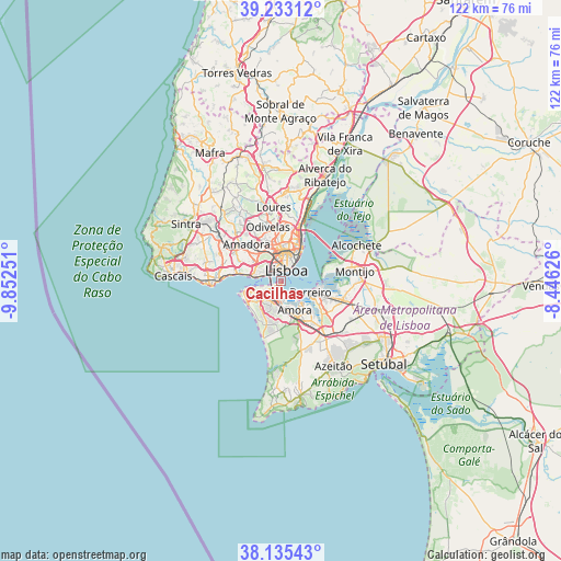
Cacilhas GPS coordinates[2]
38° 41' 10.968" North, 9° 8' 57.768" West
| Map corner | latitude | longitude |
|---|---|---|
| Upper-left | 39.23312°, | -9.85251° |
| Center: | 38.68638°, | -9.14938° |
| Lower-right: | 38.13543°, | -8.44626° |
| Map W x H: | 122.1×122.1 km | = 75.9×75.9mi |
| max Lat: | 42.11337° ⇑75.2% North |
| Cacilhas: | 38.68638° |
| min Lat: | ⇓24.8% South 32.6448° |
| min Long | Cacilhas | max Long |
| -31.17847° | -9.14938° | -6.27308° |
| W 19.7%⇐ | ⇒80.3% E |
Elevation
Elevation of Cacilhas is 1 m = 3 ft, and this is 176 m = 577 ft below average elevation for this country.
| Max E: |
1008 m = 3307 ft | 99.9% |
| Avg. | 177 m = 581 ft | |
| Cacilhas | 1 m = 3 ft | |
Min E: |
-128 m = -420 ft | 0.1% |
See also: Portugal elevation on elevation.city.
Geographical zone
Cacilhas is located in North temperate zone (between Tropic of Cancer and the Arctic Circle). Distance of this Northern Tropic circle is 1695.6 km =1053.6 mi to South.| Distance of | km | miles | from Cacilhas |
|---|---|---|---|
| North Pole | 5705.5 | 3545.2 | to North |
| Arctic Circle | 3099.7 | 1926.1 | to North |
| Tropic Cancer | 1695.6 | 1053.6 | to South |
| Equator | 4301.5 | 2672.8 | to South |


Nearby cities:
15 places around Cacilhas: (largest is in red/bold)
• Algés
7.2 km =4.5 mi,  284°
284°
• Almada
1 km =0.6 mi,  218°
218°
• Amora
7 km =4.3 mi,  155°
155°
• Barreiro
7.2 km =4.5 mi,  111°
111°
• Beato António
6.6 km =4.1 mi,  37°
37°
• Caparica
5.2 km =3.2 mi,  238°
238°
• Corroios
5.2 km =3.2 mi,  181°
181°
• Laranjeira
3.4 km =2.1 mi,  186°
186°
• Lisbon
3.6 km =2.2 mi,  22°
22°
• Piedade
2 km =1.2 mi,  203°
203°
• Pragal
2.2 km =1.4 mi,  233°
233°
• Santos-o-Velho
2.4 km =1.5 mi,  345°
345°
• Seixal
6.6 km =4.1 mi,  141°
141°
• Sobreda
5.4 km =3.4 mi, 220°
• Trafaria
7.4 km =4.6 mi,  257°
257°
Sources, notices
• [Note1] Compared only with cities in Portugal existing in our database
• [Src1] Map data: © OpenStreetMap contributors (CC-BY-SA)
• [Src2] Other city data from geonames.org with taken over terms of usage.
• [Src3] Geographical zone / Annual Mean Temperature by Robert A. Rohde @ Wikipedia
